Category:CIA World Factbook maps of Jordan
Media in category "CIA World Factbook maps of Jordan"
The following 25 files are in this category, out of 25 total.
-
 000 Jordania harta.PNG 328 × 352; 12 KB
-
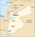
 Jo-map (German).png 351 × 377; 21 KB
-
 Jo-map.png 326 × 350; 60 KB
-
 Jo-map Amman.png 380 × 405; 96 KB
-
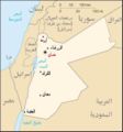
 Jo-map-HE.png 329 × 353; 8 KB
-
 Jo-map.jpg 351 × 377; 101 KB
-
 Jordan 1948-1967-ar.png 329 × 353; 29 KB
-
 Jordan 1984-1988.png 326 × 350; 9 KB
-
 Jordan 2004 CIA map.jpg 2,007 × 2,496; 1.84 MB
-
 Jordan CIA map PL.jpg 351 × 377; 20 KB
-
 Jordan CIA map.gif 325 × 349; 18 KB
-
 Jordan map.jpg 222 × 227; 9 KB
-
 Jordan Physiography.jpg 1,990 × 2,483; 1.4 MB
-
 Jordan sm01.jpg 351 × 377; 18 KB
-
 Jordan Transportation.jpg 1,990 × 2,483; 1.13 MB
-
 Jordan – U.S. area comparison.jpg 701 × 851; 381 KB
-
 Jordan-CIA WFB Map.png 329 × 354; 14 KB
-
 Jordan. LOC 2001625269.jpg 2,508 × 3,264; 716 KB
-
 Jordan. LOC 2001625269.tif 2,508 × 3,264; 23.42 MB
-
 Jordan. LOC 2004630058.jpg 2,518 × 3,278; 747 KB
-
 Jordan. LOC 91684908.tif 2,530 × 3,268; 23.66 MB
-
 Jordanie-Charte-gsw.png 351 × 377; 21 KB
-
 Jordanio.png 702 × 754; 27 KB
-
 World Factbook (1982) Jordan.jpg 589 × 589; 79 KB
-
 World Factbook (1990) Jordan.jpg 562 × 548; 116 KB

.png)


_Jordan.jpg)
_Jordan.jpg)