Category:Cabane Rambert
| Object location | | View all coordinates using: OpenStreetMap |
|---|
mountain hut  | |||||
| Upload media | |||||
| Instance of | |||||
|---|---|---|---|---|---|
| Location |
| ||||
| Owned by | |||||
| Inception |
| ||||
| Mountain range | |||||
| Elevation above sea level |
| ||||
| official website | |||||
 | |||||
Media in category "Cabane Rambert"
The following 7 files are in this category, out of 7 total.
-
 Cabane Rambert. Petit Muveran.jpg 1,216 × 912; 256 KB
-
 Corbeau à la Cabane Rambert.png 4,032 × 3,024; 56.71 MB
-
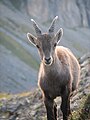 Jeune bouquetin de face.jpg 1,944 × 2,592; 1.2 MB
-
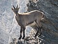 Jeune bouquetin sur un rocher.jpg 2,592 × 1,944; 1.55 MB
-
 Petit Muveron von Cabane Rambert.jpg 912 × 1,216; 299 KB
-
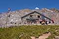 Rambert mountain refuge - panoramio.jpg 1,536 × 1,024; 361 KB
-
 Vue depuis la cabane Grand Rambert.png 4,032 × 3,024; 36.26 MB


