Category:California State Route 36
highway in California   | |||||
| Upload media | |||||
| Instance of | |||||
|---|---|---|---|---|---|
| Location |
| ||||
| Transport network |
| ||||
| Owned by | |||||
| Maintained by | |||||
| Inception |
| ||||
| Length |
| ||||
| Terminus | |||||
 | |||||
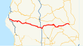
English: California State Route 36 — an east-west scenic route and Blue Star Memorial Highway, from the coast towards the Nevada border, in Northern California.
Media in category "California State Route 36"
The following 16 files are in this category, out of 16 total.
-
 California 36.svg 385 × 401; 14 KB
-

-

-
 California 36 1957.svg 601 × 625; 27 KB
-
 California State Route 36.svg 1,152 × 640; 262 KB
-
 ChesterCA1.jpg 810 × 608; 119 KB
-
 Dixie Fire damage alongside Highway 36-6088.jpg 6,123 × 3,444; 15.57 MB
-

-
 PG&E wires crossing highway 36.JPG 2,048 × 1,536; 631 KB
-
 Route 36 California wavy road.jpg 2,208 × 3,928; 2.5 MB
-
 Route 36 Veterans Memorial Humboldt County.jpg 2,208 × 3,928; 6.48 MB
-
 Vestiges of an old gas station along California Rt. 36 in Plumas County LCCN2013630933.tif 7,360 × 4,912; 206.9 MB
-
 Vestiges of an old gas station along California Rt. 36 in Plumas County LCCN2013630934.tif 7,360 × 4,912; 206.9 MB
-
 Vestiges of an old gas station along California Rt. 36 in Plumas County LCCN2013630935.tif 7,360 × 4,912; 206.9 MB
-
 Vestiges of an old gas station along California Rt. 36 in Plumas County LCCN2013630936.tif 6,590 × 4,912; 185.26 MB
-
 VolcanicLegacyScenicByway CaliforniaSection.gif 364 × 400; 66 KB


