Category:Can Xifra de Sant Dalmai
| Object location | | View all coordinates using: OpenStreetMap |
|---|
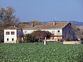
masia in Vilobí d'Onyar (Selva, Catalonia)  | |||||
| Upload media | |||||
| Instance of | |||||
|---|---|---|---|---|---|
| Location | Vilobí d'Onyar, Selva, Comarques Gironines, Catalonia | ||||
| Street address |
| ||||
| Architectural style | |||||
| Heritage designation |
| ||||
| Inception |
| ||||
| Elevation above sea level |
| ||||
 | |||||
Català: Can Xifra de Sant Dalmai (Vilobí d'Onyar)
This is a category about a building indexed in the Catalan heritage register as Bé Cultural d'Interès Local (BCIL) under the reference IPA-27237. |
Media in category "Can Xifra de Sant Dalmai"
This category contains only the following file.
-
 Can Xifra de Sant Dalmai.jpg 5,152 × 3,864; 6.47 MB