Category:Carl-Netter-Turm
| Object location | | View all coordinates using: OpenStreetMap |
|---|
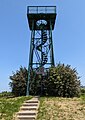
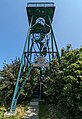
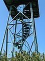
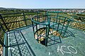
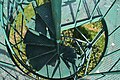
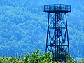
observation tower near Bühl (Baden)  | |||||
| Upload media | |||||
| Instance of | |||||
|---|---|---|---|---|---|
| Named after | |||||
| Made from material | |||||
| Location | Bühl, Bühl VVG, Rastatt district, Region Mittlerer Oberrhein, Karlsruhe Government Region, Baden-Württemberg, Germany | ||||
| Height |
| ||||
 | |||||
Subcategories
This category has only the following subcategory.
Media in category "Carl-Netter-Turm"
The following 25 files are in this category, out of 25 total.
-
 Buehl-Carl-Netter-Turm-02-2013-gje.jpg 5,184 × 3,456; 4.6 MB
-
 Buehl-Carl-Netter-Turm-04-2023-gje.jpg 2,508 × 3,527; 2.59 MB
-
 Buehl-Carl-Netter-Turm-06-2023-gje.jpg 2,802 × 4,080; 3.56 MB
-
 Buehl-Carl-Netter-Turm-08-2013-gje.jpg 3,456 × 5,184; 4.1 MB
-
 Buehl-Carl-Netter-Turm-10-2013-gje.jpg 5,184 × 3,456; 3.88 MB
-
 Buehl-Carl-Netter-Turm-12-2023-gje.jpg 3,879 × 2,639; 2.35 MB
-
 Buehl-Carl-Netter-Turm-14-Drohnenangriff-2023-gje.jpg 2,695 × 3,397; 1.8 MB
-
 Buehl-Carl-Netter-Turm-16-2023-gje.jpg 3,072 × 4,080; 2.66 MB
-
 Buehl-Carl-Netter-Turm-18-2023-gje.jpg 4,080 × 2,719; 4.79 MB
-
 Buehl-Carl-Netter-Turm-20-2023-gje.jpg 4,080 × 3,072; 5.05 MB
-
 Buehl-Carl-Netter-Turm-22-2013-gje.jpg 5,184 × 3,456; 4.99 MB
-
 Buehl-Carl-Netter-Turm-24-2023-gje.jpg 4,080 × 2,929; 2.16 MB
-
 Carl Netter Turm Eisental Schwarzwald 1.jpg 4,896 × 3,264; 6.46 MB
-
 Carl Netter Turm Eisental Schwarzwald 2.jpg 4,896 × 3,264; 6.21 MB
-
 Carl Netter Turm Eisental Schwarzwald 3.jpg 4,896 × 3,264; 7.88 MB
-
 Carl Netter Turm Eisental Schwarzwald 4.jpg 4,896 × 3,672; 8.76 MB
-
 Carl Netter Turm Eisental Schwarzwald 5.jpg 4,896 × 3,672; 8.79 MB
-
 Carl Netter Turm Eisental Schwarzwald 6.jpg 4,896 × 3,672; 9.04 MB
-
 Carl Netter Turm Eisental Schwarzwald 7.jpg 4,896 × 2,752; 7.17 MB
-
 Carl-Netter-Turm 01 fcm.jpg 4,320 × 3,240; 7.81 MB
-
 Carl-Netter-Turm 02 fcm.jpg 3,240 × 4,320; 7.06 MB
-
 Carl-Netter-Turm 03 fcm.jpg 3,716 × 2,532; 4.92 MB
-
 Carl-Netter-Turm 04 fcm.jpg 2,980 × 4,025; 7.12 MB
-
 Carl-Netter-Turm 05 fcm.jpg 3,240 × 4,320; 4.68 MB
-
 Carl-Netter-Turm 06 fcm.jpg 3,240 × 4,320; 2.5 MB


