Category:Cascade de Cerveyrieu
| Object location | | View all coordinates using: OpenStreetMap |
|---|
 | |||||
| Upload media | |||||
| Instance of | |||||
|---|---|---|---|---|---|
| Part of | |||||
| Location | |||||
| Height |
| ||||
| Mountain range | |||||
| Elevation above sea level |
| ||||
| Drainage basin | |||||
 | |||||
Media in category "Cascade de Cerveyrieu"
The following 11 files are in this category, out of 11 total.
-
 Cascade Cerveyrieu Artemare 1.jpg 5,184 × 3,456; 8.38 MB
-
 Cascade Cerveyrieu Artemare 2.jpg 3,456 × 5,184; 9.41 MB
-
 Cascade Cerveyrieu Artemare 3.jpg 5,184 × 3,456; 7.93 MB
-
 Cascade Cerveyrieu Artemare 4.jpg 5,184 × 3,456; 8.73 MB
-
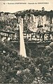 Cascade de Cerveyrieu - avant 1929 - carte postale.jpg 688 × 1,078; 585 KB
-
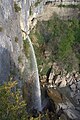
 Cascade de Cerveyrieu 01.jpg 3,456 × 4,608; 7.59 MB
-
 Cascade de Cerveyrieu et le Séran.jpg 800 × 1,200; 345 KB
-
 Cascade de Cerveyrieu...sans eau.JPG 2,448 × 3,264; 4.08 MB
-
 Cascade de Cerveyrieu.jpg 2,448 × 3,264; 1.57 MB
-
 Cascade en automne.jpg 3,456 × 2,304; 4.7 MB
-
 Cerveyrieu.jpg 700 × 934; 194 KB


