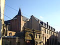
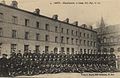
Category:Caserne du Cloître de Metz
| Object location | | View all coordinates using: OpenStreetMap |
|---|
|
This building is classé au titre des monuments historiques de la France. It is indexed in the base Mérimée, a database of architectural heritage maintained by the French Ministry of Culture, under the reference PA00106815
|
| Object location | | View all coordinates using: OpenStreetMap |
|---|
barracks  | |||||
| Upload media | |||||
| Instance of | |||||
|---|---|---|---|---|---|
| Location | Les Îles, arrondissement of Metz, Moselle, Grand Est, Metropolitan France, France | ||||
| Street address |
| ||||
| Heritage designation |
| ||||
 | |||||
Media in category "Caserne du Cloître de Metz"
The following 5 files are in this category, out of 5 total.
-
 Caserne du cloitre Abbaye St Vincent Metz 43.jpg 3,000 × 4,000; 2.49 MB
-
 Metz - caserne du cloître (1).JPG 3,264 × 2,448; 2.94 MB
-
 Metz - caserne du cloître (2).JPG 2,448 × 3,264; 3.11 MB
-
 Metz - caserne du cloître (3).JPG 3,264 × 2,448; 1.7 MB
-
 Metz Klosterkas.jpg 750 × 488; 66 KB

.JPG)
.JPG)
.JPG)