Category:Castelet hypogeum (Fontvieille)
|
This building is classé au titre des monuments historiques de la France. It is indexed in the base Mérimée, a database of architectural heritage maintained by the French Ministry of Culture, under the reference PA00081265
|
| Object location | | View all coordinates using: OpenStreetMap |
|---|
cave in France  | |||||
| Upload media | |||||
| Instance of | |||||
|---|---|---|---|---|---|
| Location | Fontvieille, canton of Arles-Est | ||||
| Street address |
| ||||
| Heritage designation |
| ||||
 | |||||
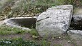
Français : Fontvieille (Alpilles, Bouches-du-Rhône, France), hypogée du Castelet, tombe datée du Chalcolithique.
Media in category "Castelet hypogeum (Fontvieille)"
The following 28 files are in this category, out of 28 total.
-
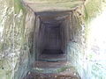 Fontvieille - Hypogée du Castelet - intérieur.jpg 3,488 × 2,616; 2.17 MB
-
 Fontvieille - Hypogée du Castelet.jpg 2,616 × 3,488; 2.14 MB
-
 Fontvieille,hypogée Castelet01.jpg 4,000 × 2,248; 6.61 MB
-
 Fontvieille,hypogée Castelet02.jpg 2,898 × 3,623; 9.05 MB
-
 Fontvieille,hypogée Castelet02a.jpg 2,248 × 4,000; 6.74 MB
-
 Fontvieille,hypogée Castelet02b.jpg 3,000 × 4,000; 9.02 MB
-
 Fontvieille,hypogée Castelet03,vestibule.jpg 3,000 × 4,000; 6.25 MB
-
 Fontvieille,hypogée Castelet04,porte.jpg 3,000 × 3,751; 5.83 MB
-
 Fontvieille,hypogée Castelet05,chambre funéraire1.jpg 3,000 × 3,750; 5.27 MB
-
 Fontvieille,hypogée Castelet06,chambre funéraire2.jpg 3,000 × 3,751; 5.4 MB
-
 Fontvieille,hypogée Castelet07,chambre funéraire3.jpg 3,000 × 3,749; 6.23 MB
-
 Fontvieille,hypogée Castelet08,chambre funéraire4.jpg 3,000 × 3,750; 5.84 MB
-
 Fontvieille,hypogée Castelet09,chambre funéraire5.jpg 3,000 × 3,751; 6.4 MB
-
 Fontvieille,hypogée Castelet10.jpg 3,000 × 3,751; 6.52 MB
-
 Fontvieille,hypogée Castelet11.jpg 3,000 × 4,000; 6.38 MB
-
 Fontvieille,hypogée Castelet12.jpg 3,000 × 3,749; 5.87 MB
-
 Fontvieille,hypogée Castelet13,première dalle couverture.jpg 4,000 × 2,248; 6.25 MB
-
 Fontvieille,hypogée Castelet14,deuxième dalle manquante1.jpg 4,000 × 2,248; 6.21 MB
-
 Fontvieille,hypogée Castelet15,deuxième dalle manquante2.jpg 4,000 × 2,248; 6.37 MB
-
 Fontvieille,hypogée Castelet16,couverture chambre funéraire1.jpg 4,000 × 2,248; 6.55 MB
-
 Fontvieille,hypogée Castelet17,couverture chambre funéraire2.jpg 4,000 × 2,248; 6.68 MB
-
 Fontvieille,hypogée Castelet18,abside.jpg 4,000 × 2,248; 6.76 MB
-
 Fontvieille,hypogée Castelet19.jpg 4,000 × 2,248; 6.49 MB
-
 Fontvieille,hypogée Castelet20.jpg 4,000 × 2,248; 5.87 MB
-
 Fontvieille,hypogée Castelet21,antichambre.jpg 4,000 × 2,248; 5.31 MB
-
 Fontvieille,hypogée Castelet22,antichambre.jpg 4,000 × 2,248; 5.35 MB
-
 Fontvieille,hypogée Castelet23,antichambre.jpg 4,000 × 2,248; 5.11 MB
-
 Fontvieille,hypogée Castelet24,cheminée.jpg 4,000 × 2,248; 6.18 MB


