Category:Castell Henllys
| Object location | | View all coordinates using: OpenStreetMap |
|---|
hillfort in Pembrokeshire  | |||||
| Upload media | |||||
| Instance of |
| ||||
|---|---|---|---|---|---|
| Location |
| ||||
| Heritage designation | |||||
| official website | |||||
 | |||||
Media in category "Castell Henllys"
The following 46 files are in this category, out of 46 total.
-
 "Iron-age " pig - geograph.org.uk - 204781.jpg 640 × 480; 157 KB
-
 "Iron-age" loom, Castell Henllys - geograph.org.uk - 272147.jpg 640 × 480; 103 KB
-
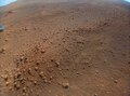
 'Castell Henllys' From Above (PIA25890).jpg 4,208 × 3,120; 2.96 MB
-
 'Castell Henllys' From Above (PIA25890).tiff 4,208 × 3,120; 37.59 MB
-
 Bed and breakfast in the Iron Age - geograph.org.uk - 1474053.jpg 640 × 480; 94 KB
-
 Castell Henllys - geograph.org.uk - 1767906.jpg 1,360 × 2,048; 682 KB
-
 Castell Henllys - geograph.org.uk - 1881661.jpg 640 × 480; 87 KB
-
 Castell Henllys - geograph.org.uk - 2761082.jpg 3,264 × 2,448; 4.6 MB
-
 Castell Henllys - geograph.org.uk - 3241508.jpg 2,000 × 1,500; 1.04 MB
-
 Castell Henllys - geograph.org.uk - 4724376.jpg 1,600 × 1,064; 669 KB
-
 Castell Henllys - geograph.org.uk - 536532.jpg 640 × 480; 129 KB
-
 Castell Henllys - geograph.org.uk - 536548.jpg 640 × 480; 140 KB
-
 Castell Henllys - geograph.org.uk - 536556.jpg 640 × 480; 175 KB
-
 Castell Henllys - geograph.org.uk - 67364.jpg 640 × 480; 94 KB
-
 Castell Henllys - panoramio.jpg 3,648 × 2,736; 2.47 MB
-
 Castell Henllys in the snow - geograph.org.uk - 1152602.jpg 640 × 502; 122 KB
-

-
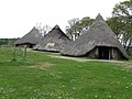
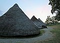
 Castell Henllys Iron Age village reconstruction - geograph.org.uk - 3067531.jpg 3,008 × 2,000; 4.98 MB
-

-

-
 Chevaux de frise at Castell Henllys - geograph.org.uk - 1473448.jpg 640 × 480; 128 KB
-

-

-
 Henllys-01.jpg 4,000 × 3,000; 2.08 MB
-
 Henllys-02.jpg 4,000 × 3,000; 2.33 MB
-
 Henllys-03.jpg 4,000 × 3,000; 1.72 MB
-
 Henllys-04.jpg 4,000 × 3,000; 1.54 MB
-
 Henllys-05.jpg 4,000 × 3,000; 3.02 MB
-
 Henllys-06.jpg 4,000 × 3,000; 2.3 MB
-
 Henllys-07.jpg 4,000 × 3,000; 1.4 MB
-

-
 Interior of one of the reconstructed houses - geograph.org.uk - 3016202.jpg 4,000 × 3,000; 3.31 MB
-
 Iron Age defences at Castell Henllys - geograph.org.uk - 1884790.jpg 480 × 640; 121 KB
-

-

-
 Pig, drinking - geograph.org.uk - 1474120.jpg 640 × 480; 103 KB
-
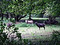
 Pigs at Castell Henllys - geograph.org.uk - 1473458.jpg 640 × 480; 117 KB
-
 Plant Dyes - Castell Henllys - geograph.org.uk - 938983.jpg 640 × 428; 126 KB
-
 Soay sheep at Castell Henllys - geograph.org.uk - 1473474.jpg 640 × 480; 148 KB
-
 Spinner of wool, Castell Henllys - geograph.org.uk - 938946.jpg 640 × 443; 75 KB
-
 Swallows' nest in a roundhouse - geograph.org.uk - 1473480.jpg 640 × 480; 99 KB
-
 That Roundhouse squat.jpg 775 × 400; 54 KB
-
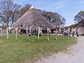
 Three houses, Castell Henllys - geograph.org.uk - 3571839.jpg 2,000 × 1,436; 1.16 MB
-
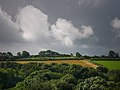 View south from Castell Henllys - geograph.org.uk - 536577.jpg 640 × 480; 71 KB
-
 Welsh housing estate (pre-Roman style) - geograph.org.uk - 2559569.jpg 480 × 640; 102 KB
-
 Wintry day, Castell Henllys - geograph.org.uk - 1625357.jpg 640 × 416; 117 KB


.jpg)


_-_geograph.org.uk_-_2559569.jpg)
