Category:Cedar Mill Creek Trestle
| Object location | | View all coordinates using: OpenStreetMap |
|---|
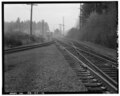
Cedar Mill Creek Trestle, in Beaverton, Oregon, is a former railroad bridge, which carried a single track, on the former Oregon Electric Railway line (later owned by Burlington Northern) located where the line crossed Cedar Mill Creek. Since October 2016, it has been part of a Tualatin Hills Park & Recreation District pedestrian trail.
The bridge is located just east of SW 158th Avenue and Merlo Road, directly adjacent to the right-of-way now used by the MAX Blue Line light rail line. The BN line was abandoned and mostly removed in early 1995, to be replaced by the new light rail line built directly adjacent (to the north). The track across the OE bridge thereafter ended just west of the bridge, and until 2000 was intermittently used for moves by Portland & Western (which had taken over the line from BN in 1995) to deliver new light-rail vehicles (LRVs) to TriMet, who installed a steel ramp and removable switch via which new LRVs were pulled off the P&W flatcar and onto the adjacent MAX tracks. That practice ended in 2000, after which TriMet began taking delivery of new LRVs by road instead of rail, and the ramp was eventually removed.
In spring 2016, the abandoned track on the trestle was removed as part of work by the Tualatin Hills Park & Recreation District to repurpose the bridge as part of a new trail at the north end of the Tualatin Hills Nature Park. The trail opened in October 2016. (This location along Cedar Mill Creek is not located in the area named Cedar Mill, which is farther to the north.)
Media in category "Cedar Mill Creek Trestle"
The following 5 files are in this category, out of 5 total.
-
 Cedar Mill Creek Trestle 01.tiff 5,000 × 4,011; 19.13 MB
-
 Cedar Mill Creek Trestle 02.tiff 5,000 × 4,020; 19.17 MB
-
 Cedar Mill Creek Trestle 03.tiff 5,000 × 4,055; 19.34 MB
-
 Cedar Mill Creek Trestle 04.tiff 5,000 × 4,041; 19.27 MB
-
 Cedar Mill Creek Trestle east end.tiff 5,000 × 4,012; 19.13 MB