Category:Château de Ragheaud
| Object location | | View all coordinates using: OpenStreetMap |
|---|
| Object location | | View all coordinates using: OpenStreetMap |
|---|
|
This building is inscrit au titre des monuments historiques de la France. It is indexed in the base Mérimée, a database of architectural heritage maintained by the French Ministry of Culture, under the reference PA00093600
|
 | |||||
| Upload media | |||||
| Instance of | |||||
|---|---|---|---|---|---|
| Location | Saint-Cernin, canton of Saint-Cernin | ||||
| Heritage designation |
| ||||
 | |||||
Media in category "Château de Ragheaud"
This category contains only the following file.
-
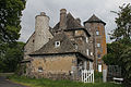 Château de Ragheaud - Façade Ouest.JPG 4,960 × 3,304; 2.8 MB