Category:Chamorga
| Camera location | | View all coordinates using: OpenStreetMap |
|---|
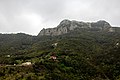
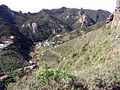
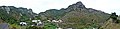
English: Pictures of Chamorga, a village belongs to the municipality of Santa Cruz de Tenerife, in the northeastern part of the island of Tenerife one of the islands of the Canary Islands in Spain. Chamorga is near the Anaga Massif and the mountain range Macizo de Anaga
  | |||||
| Upload media | |||||
| Location |
| ||||
|---|---|---|---|---|---|
 | |||||
Subcategories
This category has the following 4 subcategories, out of 4 total.
- Maps of Chamorga (1 F)
B
- Barranco de Chamorga (8 F)
N
- Nature of Chamorga (17 F)
R
- Roque del Pilón (4 F)
Media in category "Chamorga"
The following 20 files are in this category, out of 20 total.
-
 At Tenerife 2019 239.jpg 5,184 × 3,456; 10.41 MB
-
 At Tenerife 2019 240.jpg 5,184 × 3,456; 14.46 MB
-
 At Tenerife 2019 241.jpg 5,184 × 3,456; 13.02 MB
-
 At Tenerife 2019 242.jpg 5,184 × 3,456; 11.42 MB
-
 At Tenerife 2019 243.jpg 5,184 × 3,456; 10.59 MB
-
 At Tenerife 2019 244.jpg 5,184 × 3,456; 11.11 MB
-
 At Tenerife 2019 246.jpg 5,184 × 3,456; 11.78 MB
-
 At Tenerife 2019 248.jpg 5,184 × 3,456; 11.64 MB
-
 At Tenerife 2019 249.jpg 5,184 × 3,456; 13.58 MB
-
 At Tenerife 2019 256.jpg 5,184 × 3,456; 11.06 MB
-
 At Tenerife 2019 259.jpg 5,184 × 3,456; 12.02 MB
-
 At Tenerife 2019 265.jpg 5,184 × 3,456; 12.79 MB
-
 At Tenerife 2019 290.jpg 9,726 × 3,830; 20.82 MB
-
 At Tenerife 2019 291.jpg 8,776 × 3,876; 19.89 MB
-
 Caserío de Chamorga.jpg 2,048 × 1,536; 369 KB
-
 Chamorga I.jpg 567 × 425; 42 KB
-
 Chamorga II.jpg 567 × 425; 58 KB
-
 Chamorga, Macizo de Anaga, Tenerife, Spain 35.jpg 4,450 × 2,783; 8.51 MB
-
 Ermita de Chamorga (Tenerife).JPG 2,048 × 1,536; 1.4 MB
-
 Vista de Chamorga1.jpg 11,918 × 2,919; 8.53 MB


.JPG)