Category:Champ des Tombes (Saint-Broladre)
| Object location | | View all coordinates using: OpenStreetMap |
|---|
|
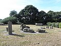
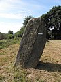
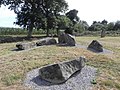
This building is inscrit au titre des monuments historiques de la France. It is indexed in the base Mérimée, a database of architectural heritage maintained by the French Ministry of Culture, under the reference PA00090765
|
_Hemicycle_m%C3%A9galithique_dit_Les_Tombes_01.JPG) | |||||
| Upload media | |||||
| Instance of | |||||
|---|---|---|---|---|---|
| Location | Saint-Broladre, canton of Pleine-Fougères | ||||
| Heritage designation |
| ||||
 | |||||
Media in category "Champ des Tombes (Saint-Broladre)"
The following 6 files are in this category, out of 6 total.
-
 Saint-Broladre (35) Hemicycle mégalithique dit Les Tombes 01.JPG 2,381 × 1,786; 2.38 MB
-
 Saint-Broladre (35) Hemicycle mégalithique dit Les Tombes 02.JPG 1,786 × 2,381; 2.48 MB
-
 Saint-Broladre (35) Hemicycle mégalithique dit Les Tombes 03.JPG 2,381 × 1,786; 2.75 MB
-
 Saint-Broladre (35) Hemicycle mégalithique dit Les Tombes 04.JPG 2,381 × 1,786; 2.56 MB
-
 Saint-Broladre (35) Hemicycle mégalithique dit Les Tombes 05.JPG 2,381 × 1,786; 2.93 MB
-
 Saint-Broladre (35) Hemicycle mégalithique dit Les Tombes 06.JPG 2,381 × 1,786; 3.01 MB
_Hemicycle_m%C3%A9galithique_dit_Les_Tombes_02.JPG)
_Hemicycle_m%C3%A9galithique_dit_Les_Tombes_03.JPG)
_Hemicycle_m%C3%A9galithique_dit_Les_Tombes_04.JPG)
_Hemicycle_m%C3%A9galithique_dit_Les_Tombes_05.JPG)
_Hemicycle_m%C3%A9galithique_dit_Les_Tombes_06.JPG)