Home
Random
Nearby
Log in
Settings
Donate
About Wikimedia Commons
Disclaimers
Search
Category
:
Chandler Falls
Language
Watch
Edit
Maricopa County, Arizona.
Media in category "Chandler Falls"
The following 4 files are in this category, out of 4 total.
Building new Chandler Falls Power Plant, view showing installation of penstock. Photographer- Unknown, c. 1919. Source- SRPA - Tempe Canal, South Side Salt River in Tempe, Mesa HAER ARIZ,7-TEMP,7-3.tif
5,000 × 3,975; 18.96 MB
Chandler Falls site, before razing. Photographer- Unknown, c. 1950. Source- SRPA - Tempe Canal, South Side Salt River in Tempe, Mesa and Phoenix, Tempe, Maricopa County, AZ HAER ARIZ,7-TEMP,7-4.tif
5,105 × 4,060; 19.77 MB
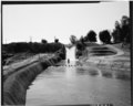
Chandler Falls, looking downstream, and downhill from the edge of the mesa (from south). Penstock and foundation of the hydropower plant visible on left. Photographer- Mark Durben HAER ARIZ,7-TEMP,7-8.tif
5,000 × 4,013; 19.14 MB
Chandler Falls, looking upstream (from north). Golf tee of the Mesa Country Club on right. Photographer- Mark Durben, February 1989. Source- SRPA - Tempe Canal, South Side Salt HAER ARIZ,7-TEMP,7-7.tif
5,000 × 3,994; 19.05 MB