Category:Chapel of Wendelin in Hellikon
| Object location | | View all coordinates using: OpenStreetMap |
|---|
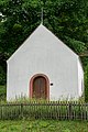
church building in Hellikon in the canton of Aargau, Switzerland  | |||||
| Upload media | |||||
| Instance of | |||||
|---|---|---|---|---|---|
| Part of | |||||
| Named after | |||||
| Location | Hellikon, Rheinfelden District, Aargau, Switzerland | ||||
| Street address |
| ||||
| Diocese | |||||
| Heritage designation | |||||
 | |||||
Media in category "Chapel of Wendelin in Hellikon"
The following 2 files are in this category, out of 2 total.
-
 2018-Hellikon-St-Wendelinskapelle-II.jpg 1,920 × 1,280; 3.05 MB
-
 2018-Hellikon-Wendelinskapelle.jpg 1,280 × 1,920; 2.81 MB
