Category:Chapelle Notre-Dame-de-Bon-Secours des Champs-Géraux
| Object location | | View all coordinates using: OpenStreetMap |
|---|
|
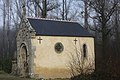
This building is indexed in the base Mérimée, a database of architectural heritage maintained by the French Ministry of Culture, under the reference IA00004881
|
chapel located in Côtes-d'Armor, in France .jpg) | |||||
| Upload media | |||||
| Instance of | |||||
|---|---|---|---|---|---|
| Location | Les Champs-Géraux, canton of Évran | ||||
| Heritage designation | |||||
 | |||||
Media in category "Chapelle Notre-Dame-de-Bon-Secours des Champs-Géraux"
The following 7 files are in this category, out of 7 total.
-
 Chapelle Notre-Dame de Bon Secours (D 794 - Côtes d'Armor).JPG 2,998 × 2,230; 3.35 MB
-
 La chapelle de bon secours - panoramio (1).jpg 3,000 × 4,000; 3.9 MB
-
 La chapelle de bon secours - panoramio (2).jpg 3,000 × 4,000; 4.07 MB
-
 La chapelle de bon secours - panoramio (3).jpg 4,000 × 3,000; 4.94 MB
-
 La chapelle de bon secours - panoramio.jpg 3,000 × 4,000; 3.99 MB
-
 Les Champs-Géraux - Chapelle ND de Bonsecours 01.JPG 5,760 × 3,840; 5.12 MB
-
 Les Champs-Géraux - Chapelle ND de Bonsecours 02.JPG 5,760 × 3,840; 11.51 MB
.JPG)
.jpg)
.jpg)


