Category:Chapelle Saint-Étienne de Saint-Hilaire-d'Ozilhan
| Object location | | View all coordinates using: OpenStreetMap |
|---|
|
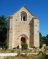
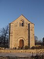
This building is inscrit au titre des monuments historiques de la France. It is indexed in the base Mérimée, a database of architectural heritage maintained by the French Ministry of Culture, under the reference PA00132869
|
chapel located in Gard, in France  | |||||
| Upload media | |||||
| Instance of | |||||
|---|---|---|---|---|---|
| Dedicated to | |||||
| Location | Saint-Hilaire-d'Ozilhan, canton of Remoulins | ||||
| Heritage designation |
| ||||
 | |||||
Media in category "Chapelle Saint-Étienne de Saint-Hilaire-d'Ozilhan"
The following 7 files are in this category, out of 7 total.
-
 Chapelle Saint-Étienne de Saint-Hilaire-d'Ozilhan 01.JPG 3,483 × 2,323; 4.76 MB
-
 Chapelle Saint-Étienne de Saint-Hilaire-d'Ozilhan 02.JPG 2,592 × 3,218; 5.18 MB
-
 Chapelle Saint-Étienne de Saint-Hilaire-d'Ozilhan 03.JPG 2,592 × 3,138; 4.5 MB
-
 Chapelle Saint-Étienne de Saint-Hilaire-d'Ozilhan 04.JPG 2,448 × 3,681; 5.53 MB
-
 Chapelle Saint-Étienne de Saint-Hilaire-d'Ozilhan 05.JPG 3,872 × 2,592; 4.97 MB
-
 Chapelle Saint-Étienne de Saint-Hilaire-d'Ozilhan 06.JPG 2,592 × 3,872; 5.17 MB
-
 Chiesa di St Etienne de la Clastre - St Hilaire d'Ozilhan - O3436.jpg 1,680 × 2,240; 707 KB


