Category:Chapelle Saint-Fiacre de Gurunhuel
| Object location | | View all coordinates using: OpenStreetMap |
|---|
|
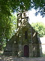
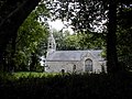
This building is inscrit au titre des monuments historiques de la France. It is indexed in the base Mérimée, a database of architectural heritage maintained by the French Ministry of Culture, under the reference PA00089193
|
chapel located in Côtes-d'Armor, in France  | |||||
| Upload media | |||||
| Instance of | |||||
|---|---|---|---|---|---|
| Location | Gurunhuel, canton of Belle-Isle-en-Terre | ||||
| Street address |
| ||||
| Heritage designation |
| ||||
 | |||||
Media in category "Chapelle Saint-Fiacre de Gurunhuel"
The following 5 files are in this category, out of 5 total.
-
 Chapelle Saint-Fiacre de Gurunhuel 01.JPG 2,560 × 1,920; 3.38 MB
-
 Chapelle Saint-Fiacre de Gurunhuel 02.JPG 1,920 × 2,560; 3.36 MB
-
 Gurunhuel. Saint Fiacre 2.jpg 1,280 × 960; 211 KB
-
 Gurunhuel. Saint Fiacre 3.jpg 1,280 × 960; 204 KB
-
 Gurunhuel. Saint-Fiacre 1.jpg 1,280 × 960; 212 KB


