Category:Chapelle Saint-Hubert de Courcelles
| Object location | | View all coordinates using: OpenStreetMap |
|---|
|
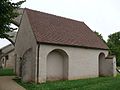
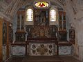
This building is inscrit au titre des monuments historiques de la France. It is indexed in the base Mérimée, a database of architectural heritage maintained by the French Ministry of Culture, under the reference PA00099045
|
chapel located in Loiret, in France _-_Chapelle_Saint-Hubert_-_1.jpg) _-_Chapelle_Saint-Hubert_-_5.jpg) | |||||
| Upload media | |||||
| Instance of | |||||
|---|---|---|---|---|---|
| Part of | |||||
| Location | Courcelles-le-Roi, canton of Beaune-la-Rolande | ||||
| Diocese | |||||
| Heritage designation |
| ||||
 | |||||
Media in category "Chapelle Saint-Hubert de Courcelles"
The following 10 files are in this category, out of 10 total.
-
 Courcelles (Loiret) - Chapelle Saint-Hubert - 1.jpg 1,824 × 1,368; 512 KB
-
 Courcelles (Loiret) - Chapelle Saint-Hubert - 10.jpg 1,824 × 1,368; 349 KB
-
 Courcelles (Loiret) - Chapelle Saint-Hubert - 2.jpg 1,824 × 1,368; 636 KB
-
 Courcelles (Loiret) - Chapelle Saint-Hubert - 3.jpg 1,824 × 1,368; 623 KB
-
 Courcelles (Loiret) - Chapelle Saint-Hubert - 4.jpg 1,824 × 1,368; 380 KB
-
 Courcelles (Loiret) - Chapelle Saint-Hubert - 5.jpg 1,824 × 1,368; 451 KB
-
 Courcelles (Loiret) - Chapelle Saint-Hubert - 6.jpg 1,824 × 1,368; 477 KB
-
 Courcelles (Loiret) - Chapelle Saint-Hubert - 7.jpg 1,824 × 1,368; 338 KB
-
 Courcelles (Loiret) - Chapelle Saint-Hubert - 8.jpg 1,824 × 1,368; 303 KB
-
 Courcelles (Loiret) - Chapelle Saint-Hubert - 9.jpg 1,824 × 1,368; 430 KB
_-_Chapelle_Saint-Hubert_-_10.jpg)
_-_Chapelle_Saint-Hubert_-_2.jpg)
_-_Chapelle_Saint-Hubert_-_3.jpg)
_-_Chapelle_Saint-Hubert_-_4.jpg)
_-_Chapelle_Saint-Hubert_-_6.jpg)
_-_Chapelle_Saint-Hubert_-_7.jpg)
_-_Chapelle_Saint-Hubert_-_8.jpg)
_-_Chapelle_Saint-Hubert_-_9.jpg)