Category:Charlton Marshall
English: Charlton Marshall is a village in north Dorset, England, situated beside the River Stour on the A350 road two miles south of the market town Blandford Forum. The village has a population of 1,150 (2001).
village and civil parish in Dorset, United Kingdom  | |||||
| Upload media | |||||
| Instance of | |||||
|---|---|---|---|---|---|
| Location | Dorset, South West England, England | ||||
| Population |
| ||||
 | |||||
Subcategories
This category has the following 3 subcategories, out of 3 total.
S
T
Media in category "Charlton Marshall"
The following 96 files are in this category, out of 96 total.
-
 A350 through Charlton Marshall - geograph.org.uk - 5725102.jpg 640 × 428; 115 KB
-
 A350 through Charlton Marshall - geograph.org.uk - 5725117.jpg 640 × 428; 96 KB
-
 A354 towards Dorchester - geograph.org.uk - 5964148.jpg 1,024 × 684; 186 KB
-
 A354 towards Dorchester - geograph.org.uk - 5964153.jpg 1,024 × 684; 172 KB
-
 A354 towards Dorchester - geograph.org.uk - 5964293.jpg 1,024 × 684; 175 KB
-
 Activity Centre on Charlton Down - geograph.org.uk - 3346226.jpg 640 × 480; 58 KB
-
 Birch Close - geograph.org.uk - 3471522.jpg 640 × 480; 73 KB
-
 Bridle Path and Track - geograph.org.uk - 3346218.jpg 640 × 480; 113 KB
-
 Bus request stop, A354 - geograph.org.uk - 1174605.jpg 640 × 480; 151 KB
-
 Bus stop at road junction in Charlton on the Hill - geograph.org.uk - 4834623.jpg 1,600 × 1,066; 239 KB
-

-
 Charlton Marshall - geograph.org.uk - 2946771.jpg 640 × 464; 60 KB
-
 Charlton Marshall Ford - geograph.org.uk - 6619673.jpg 4,032 × 3,024; 5.37 MB
-
 Charlton Marshall, church room - geograph.org.uk - 2778552.jpg 1,024 × 768; 149 KB
-
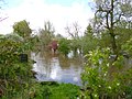 Charlton Marshall, flooded gardens - geograph.org.uk - 2918848.jpg 1,024 × 768; 247 KB
-
 Charlton Marshall, former railway bridge - geograph.org.uk - 2778525.jpg 1,024 × 768; 279 KB
-
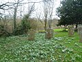 Charlton Marshall, gravestones - geograph.org.uk - 2815817.jpg 1,024 × 768; 324 KB
-

-
-

-

-
 Charlton Marshall, River Stour - geograph.org.uk - 2815809.jpg 1,024 × 768; 192 KB
-
 Charlton Marshall, snowdrops - geograph.org.uk - 2815814.jpg 1,024 × 768; 318 KB
-
 Charlton Marshall, village pump - geograph.org.uk - 2778538.jpg 1,024 × 768; 130 KB
-
 Country Lane - geograph.org.uk - 3346237.jpg 640 × 480; 91 KB
-
 Cows at Lophill Farm, Langton Long - geograph.org.uk - 295118.jpg 600 × 450; 93 KB
-
 Drive to Birch Close Farm - geograph.org.uk - 454910.jpg 640 × 480; 104 KB
-
 Drive to Charisworth - geograph.org.uk - 1174580.jpg 640 × 480; 165 KB
-
 Fields at Thornicombe - geograph.org.uk - 3291680.jpg 640 × 480; 52 KB
-
 Fields of Stubble Swede - geograph.org.uk - 3341584.jpg 640 × 480; 91 KB
-
 Footpath at Charlton on the Hill - geograph.org.uk - 3471497.jpg 640 × 480; 117 KB
-
 Ford, Charlton Marshall - geograph.org.uk - 2305263.jpg 640 × 480; 94 KB
-
 Ford, Charlton Marshall, Dorset - geograph.org.uk - 1358084.jpg 1,600 × 1,200; 567 KB
-
 Gorcombe Farm - geograph.org.uk - 3346191.jpg 640 × 480; 70 KB
-
 Holly Brake - geograph.org.uk - 3346232.jpg 640 × 480; 75 KB
-
 Langton Nurseries - geograph.org.uk - 295122.jpg 600 × 450; 87 KB
-
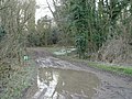 Muddy Puddle - geograph.org.uk - 330363.jpg 640 × 480; 128 KB
-
 Powerlines - geograph.org.uk - 3470201.jpg 640 × 480; 84 KB
-
 Road through Charlton Marshall - geograph.org.uk - 322782.jpg 640 × 430; 133 KB
-
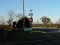
 Sign of the times - geograph.org.uk - 371833.jpg 640 × 480; 94 KB
-
 Snowdrops in Rendezvous Plantation - geograph.org.uk - 329032.jpg 640 × 480; 147 KB
-
 Telephone box, Charlton on the Hill - geograph.org.uk - 1174400.jpg 640 × 480; 152 KB
-
 Telephone box, Thornicombe - geograph.org.uk - 1174497.jpg 640 × 480; 87 KB
-
 View from Charlton Marshall - geograph.org.uk - 322783.jpg 640 × 430; 114 KB
-
 Weather vane, Thornicombe - geograph.org.uk - 1174555.jpg 640 × 480; 68 KB
-
 Birch Close Farm - geograph.org.uk - 329161.jpg 640 × 480; 67 KB
-

-
 Bridleway to South Farm - geograph.org.uk - 330403.jpg 640 × 480; 70 KB
-

-
 Bridleway towards Rendezvous Plantation - geograph.org.uk - 329259.jpg 640 × 480; 134 KB
-
 Caught Knapping - geograph.org.uk - 371828.jpg 640 × 480; 90 KB
-

-
 Cistern near Gorcombe - geograph.org.uk - 329249.jpg 640 × 480; 81 KB
-
 Commercial activity at Gorcombe - geograph.org.uk - 329203.jpg 640 × 480; 80 KB
-
 Copse near Gorcombe - geograph.org.uk - 329235.jpg 640 × 480; 112 KB
-
 Dorset fields - geograph.org.uk - 329282.jpg 640 × 480; 82 KB
-
 End of the track - geograph.org.uk - 371734.jpg 640 × 480; 134 KB
-
 Farm track - geograph.org.uk - 329185.jpg 640 × 480; 88 KB
-
 Field Gate - geograph.org.uk - 329125.jpg 640 × 480; 101 KB
-
 Field gate near Gorcombe Farm - geograph.org.uk - 454898.jpg 640 × 480; 121 KB
-
 Footpath - geograph.org.uk - 329060.jpg 480 × 640; 144 KB
-
 Footpath at Charlton on the Hill - geograph.org.uk - 455704.jpg 640 × 480; 155 KB
-
 Footpath to Great Coll Wood - geograph.org.uk - 330372.jpg 640 × 480; 133 KB
-
 Footpath to Manor Farm - geograph.org.uk - 329172.jpg 640 × 480; 108 KB
-
 Gateway on Bridleway - geograph.org.uk - 329268.jpg 640 × 480; 166 KB
-
 Glebe Farm - Barn - geograph.org.uk - 329144.jpg 640 × 480; 104 KB
-
 Glebe Farm - Farmhouse - geograph.org.uk - 329137.jpg 640 × 480; 89 KB
-
 Glebe Farm - geograph.org.uk - 329131.jpg 640 × 480; 86 KB
-
 Gorcombe Farm - geograph.org.uk - 329069.jpg 640 × 480; 82 KB
-
 Green House Effect^ - geograph.org.uk - 371806.jpg 640 × 480; 116 KB
-
 Heading South-West - geograph.org.uk - 371847.jpg 640 × 480; 105 KB
-
 Lane to Glebe Farm - geograph.org.uk - 329116.jpg 640 × 480; 91 KB
-
 Lane to Gorcombe Farm - geograph.org.uk - 334638.jpg 640 × 480; 169 KB
-
 Large Agricultural Beastie - geograph.org.uk - 371872.jpg 480 × 640; 96 KB
-
 Late afternoon on Charlton Down - geograph.org.uk - 330360.jpg 640 × 480; 114 KB
-
 Lophill Farm, Langton Long - geograph.org.uk - 295120.jpg 600 × 450; 68 KB
-
 Maggot Clump - geograph.org.uk - 371739.jpg 640 × 480; 100 KB
-
 Magnificent Oak - geograph.org.uk - 331517.jpg 640 × 480; 92 KB
-
 Manor Farm - geograph.org.uk - 329155.jpg 640 × 480; 101 KB
-
-
 New Build - geograph.org.uk - 329214.jpg 640 × 480; 98 KB
-
 Nice Barn - geograph.org.uk - 371726.jpg 640 × 480; 107 KB
-
 North Farm - geograph.org.uk - 328995.jpg 640 × 480; 98 KB
-
 Oil Seed Rape Field, Thornicombe - geograph.org.uk - 371818.jpg 640 × 480; 112 KB
-
 Quad Bike Course at Gorcombe - geograph.org.uk - 329224.jpg 640 × 480; 59 KB
-
 Rendezvous Plantation - geograph.org.uk - 329302.jpg 640 × 480; 94 KB
-

-
 Rural Track, near Blandford St Mary - geograph.org.uk - 371729.jpg 640 × 480; 101 KB
-

-
 Silo at North Farm - geograph.org.uk - 331510.jpg 640 × 480; 95 KB
-
 Southern Edge of Little Coll Wood - geograph.org.uk - 337592.jpg 640 × 428; 113 KB
-
 Thornicombe - geograph.org.uk - 295134.jpg 600 × 450; 57 KB
-
 Thornicombe - geograph.org.uk - 295136.jpg 600 × 450; 64 KB
-
 Track to Manor Farm - geograph.org.uk - 329190.jpg 640 × 480; 94 KB
-
 View towards Holly Brake - geograph.org.uk - 329295.jpg 640 × 480; 83 KB
-


