Category:Cherry Island Range Rear Light
| Object location | | View all coordinates using: OpenStreetMap |
|---|
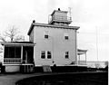
English: Cherry Island Range Rear Light
lighthouse in Delaware, United States  | |||||
| Upload media | |||||
| Instance of | |||||
|---|---|---|---|---|---|
| Location | New Castle County, Delaware | ||||
| Located in or next to body of water | |||||
| Service entry |
| ||||
| Service retirement |
| ||||
| Inception |
| ||||
| Height |
| ||||
 | |||||
Media in category "Cherry Island Range Rear Light"
This category contains only the following file.
-
 Cherry island rear light.JPG 461 × 363; 36 KB