Category:Choi Wing Road Park
| Object location | | View all coordinates using: OpenStreetMap |
|---|
| Upload media | |||||
| Instance of | |||||
|---|---|---|---|---|---|
| Location | Kwun Tong District, Hong Kong, PRC | ||||
 | |||||
Media in category "Choi Wing Road Park"
The following 6 files are in this category, out of 6 total.
-
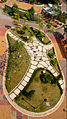
 CHOI WING RD PK LEVEL2 2010AUG.jpg 3,648 × 2,736; 5.06 MB
-
 Choi Wing Road Park entrance 201309.jpg 1,600 × 1,066; 472 KB
-
 Choi Wing Road Park, elevator (Hong Kong).jpg 4,424 × 2,946; 5.49 MB
-
 Choi Wing Road Park, Rock Display Area (Hong Kong).jpg 4,494 × 2,990; 9.11 MB
-
 RainbowRock1.jpg 901 × 1,600; 2.69 MB
-
 RainbowRock2.jpg 1,550 × 847; 1.9 MB


.jpg)
.jpg)

