Category:Chrüzlipass
 | |||||
| Upload media | |||||
| Instance of | |||||
|---|---|---|---|---|---|
| Location | |||||
| Mountain range | |||||
| Elevation above sea level |
| ||||
 | |||||
![]() Switzerland
Switzerland ![]() Valais
Valais ![]() Graubünden - 2.347 m u. M.
Graubünden - 2.347 m u. M.
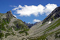
English: The Chrüzlipass is a high mountain pass of the Glarus Alps, located on the border between the Swiss cantons of Uri and Graubünden. It connects Amsteg (Uri) and Sedrun (Graubünden), is one of the lowest passes between the two cantons and traversed by a trail.
The pass is overlooked by the Witenalpstock and the Chrüzlistock.
The pass is overlooked by the Witenalpstock and the Chrüzlistock.
Media in category "Chrüzlipass"
The following 3 files are in this category, out of 3 total.
-
 Chrüzlipass.jpg 3,840 × 2,160; 5.38 MB
-
 ETH-BIB-Portlilücke, Chrüzlipass, Oberalpstock v. W. aus 4000 m-Inlandflüge-LBS MH01-002401.tif 6,294 × 4,383; 79.12 MB
-
 Picswiss UR-22-03.jpg 500 × 333; 59 KB
