Category:Church Rock (Utah)
landform  | |||||
| Upload media | |||||
| Instance of | |||||
|---|---|---|---|---|---|
| Made from material | |||||
| Location | San Juan County, Utah | ||||
| Elevation above sea level |
| ||||
 | |||||
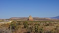
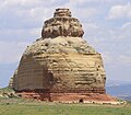
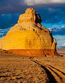
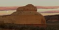
English: Media related to Church Rock (Utah), a solitary column of sandstone in southern Utah along the eastern side of U.S. Route 191, between Moab and Monticello, and near the entrance to the Needles District of Canyonlands National Park.
Media in category "Church Rock (Utah)"
The following 22 files are in this category, out of 22 total.
-
 2013-09-22 16 24 09 Church Rock viewed from U.S. Route 191.JPG 3,264 × 2,448; 1.77 MB
-
 2016.10.21 Utah (2).jpg 3,008 × 1,692; 3.32 MB
-
 Church Rock (Utah) - panoramio.jpg 1,600 × 1,200; 830 KB
-
 Church Rock (Utah) on U.S. Route 191 (3455928800).jpg 2,784 × 1,856; 1 MB
-
 Church Rock - Flickr - brewbooks.jpg 3,264 × 2,034; 2.48 MB
-
 Church Rock - Utah.jpg 1,600 × 1,200; 668 KB
-
 Church Rock Canyonlands National Park.jpg 2,934 × 2,053; 2.74 MB
-
 Church Rock from U.S. 191.jpeg 1,600 × 1,406; 302 KB
-
 Church Rock Utah 1.jpg 2,272 × 1,704; 638 KB
-
 Church Rock, near the turnoff from Moab (8227778089).jpg 640 × 269; 62 KB
-
 Church Rock, south of Moab, UT (8226434548).jpg 500 × 640; 111 KB
-
 Desert Sunset (6274446664).jpg 2,388 × 1,242; 531 KB
-
 Formation in the Utah desert LCCN2011634805.tif 3,133 × 2,193; 39.34 MB
-
 North at Church Rock in Utah, Oct 09.jpg 3,296 × 2,472; 977 KB
-
 North northeast at Church Rock in Utah, Jun 05.jpg 1,280 × 960; 319 KB
-
 NRCSUT03016 - Utah (6401)(NRCS Photo Gallery).jpg 2,100 × 1,500; 4.98 MB
-
 NRCSUT03016 - Utah (6401)(NRCS Photo Gallery).tif 2,100 × 1,500; 12.02 MB
-
 OldSpanishTrailUT.gif 765 × 600; 84 KB
-
 Sideview of Church Rock.jpeg 1,600 × 753; 194 KB
-
 US 191 & Utah Route 211 Markers.jpg 2,448 × 3,264; 3.67 MB
-
 US Highway 191 - Utah - 7688680770.jpg 3,072 × 2,304; 384 KB
-
 Ô (4890256994).jpg 1,280 × 853; 134 KB

.jpg)
_-_panoramio.jpg)
_on_U.S._Route_191_(3455928800).jpg)


.jpg)
.jpg)
.jpg)


(NRCS_Photo_Gallery).jpg)


.jpg)