Category:Church of Holderbank SO
| Object location | | View all coordinates using: OpenStreetMap |
|---|
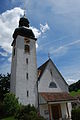
church building in Holderbank in the canton of Solothurn, Switzerland   | |||||
| Upload media | |||||
| Instance of | |||||
|---|---|---|---|---|---|
| Part of | |||||
| Location | Holderbank, Thal District, Thal-Gäu, Solothurn, Switzerland | ||||
| Street address |
| ||||
| Diocese | |||||
| Heritage designation | |||||
 | |||||
Media in category "Church of Holderbank SO"
The following 10 files are in this category, out of 10 total.
-
 Holderbank SO 463.JPG 3,872 × 2,592; 4.13 MB
-
 Holderbank SO 464.JPG 3,872 × 2,592; 3.96 MB
-
 Holderbank SO preghejo 465.JPG 2,592 × 3,872; 3.59 MB
-
 Holderbank SO preghejo 466.JPG 2,592 × 3,872; 3.61 MB
-
 Holderbank SO preghejo 468.JPG 3,872 × 2,592; 3.92 MB
-
 Holderbank SO preghejo 469.JPG 2,592 × 3,872; 3.66 MB
-
 Holderbank SO preghejo 470.JPG 3,872 × 2,592; 3.25 MB
-
 Holderbank SO preghejo 471.JPG 2,592 × 3,872; 4.05 MB
-
 Holderbank SO preghejo 472.JPG 3,872 × 2,592; 3.74 MB
-
 Holderbank SO preghejo 473.JPG 3,872 × 2,592; 3.65 MB


