Category:Church of Our Most Merciful Savior (Santee, Nebraska)
| Object location | | View all coordinates using: OpenStreetMap |
|---|
church building in Nebraska, United States of America  | |||||
| Upload media | |||||
| Instance of | |||||
|---|---|---|---|---|---|
| Location | Nebraska | ||||
| Heritage designation |
| ||||
 | |||||
Media in category "Church of Our Most Merciful Savior (Santee, Nebraska)"
The following 4 files are in this category, out of 4 total.
-
 Episcopal church on the Santee Reservation.jpg 4,270 × 3,324; 1.57 MB
-
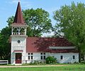 Most Merciful Savior, Santee, from S 1.JPG 1,720 × 1,450; 946 KB
-
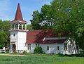 Most Merciful Savior, Santee, from SE 1.JPG 1,678 × 1,279; 982 KB
-
 Most Merciful Savior, Santee, from SW 1.JPG 1,789 × 1,584; 1.1 MB


