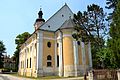
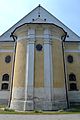
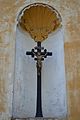
Category:Church of Saint Stephen of Hungary (Jablonica)
| This category shows the protected monument with the number 205-618/1 (other) in the Slovak Republic. |
| Object location | | View all coordinates using: OpenStreetMap |
|---|
 | |||||
| Upload media | |||||
| Instance of | |||||
|---|---|---|---|---|---|
| Location | Jablonica, Senica District, Trnava Region, Slovakia | ||||
| Architectural style | |||||
| Heritage designation |
| ||||
| Inception |
| ||||
 | |||||
Media in category "Church of Saint Stephen of Hungary (Jablonica)"
The following 13 files are in this category, out of 13 total.
-
 Jablonica church.jpg 500 × 623; 86 KB
-
 Jablonica kostol 01.jpg 3,456 × 2,304; 1.94 MB
-
 Jablonica kostol 04.jpg 2,304 × 3,456; 1.38 MB
-
 Jablonica kostol 05.jpg 2,304 × 3,456; 1.61 MB
-
 Jablonica kostol 06.jpg 2,304 × 3,456; 1.51 MB
-
 Jablonica kostol 07.jpg 2,304 × 3,456; 1.01 MB
-
 Jablonica kostol 09.jpg 2,304 × 3,456; 1.76 MB
-
 Jablonica kostol 11.jpg 2,304 × 3,456; 1.38 MB
-
 Jablonica kostol 13.jpg 3,456 × 2,304; 1,017 KB
-
 Jablonica kostol 14.jpg 2,304 × 3,456; 1.46 MB
-
 Slovak Republic - Jablonica (1).JPG 2,592 × 3,872; 2.94 MB
-
 Slovak Republic - Jablonica (3).JPG 2,592 × 3,872; 3.59 MB
-
 Slovak Republic - Jablonica.JPG 2,592 × 3,872; 3.36 MB


.JPG)
.JPG)
