Category:Church of Virgin Mary of Sorrows (Vajnory)
| Camera location | | View all coordinates using: OpenStreetMap |
|---|
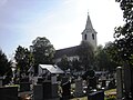
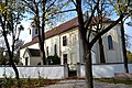
church building in Vajnory, Slovakia  | |||||
| Upload media | |||||
| Instance of | |||||
|---|---|---|---|---|---|
| Patron saint | |||||
| Location | Vajnory, Bratislava, Bratislava Region, Slovakia | ||||
| Architectural style |
| ||||
| Diocese | |||||
| Heritage designation |
| ||||
| Inception |
| ||||
 | |||||
| This category shows the protected monument with the number 103-328/0 (other) in the Slovak Republic. |
Media in category "Church of Virgin Mary of Sorrows (Vajnory)"
The following 16 files are in this category, out of 16 total.
-
 Church of Virgin Mary of Sorrows, Vajnory, Bratislava.jpg 2,048 × 1,536; 1.29 MB
-
 Vajnory 12.JPG 997 × 1,329; 587 KB
-
 Vajnory kostol 01.jpg 3,456 × 2,304; 2.53 MB
-
 Vajnory kostol 02.jpg 3,456 × 2,304; 1.51 MB
-
 Vajnory kostol 03.jpg 3,456 × 2,304; 1.45 MB
-
 Vajnory kostol 04.jpg 2,304 × 3,456; 1.28 MB
-
 Vajnory kostol 05.jpg 3,456 × 2,304; 2.36 MB
-
 Vajnory kostol 06.jpg 2,304 × 3,456; 1.22 MB
-
 Vajnory kostol 07.jpg 3,456 × 2,304; 1.28 MB
-
 Vajnory kostol 08.jpg 2,304 × 3,456; 1.37 MB
-
 Vajnory kostol 09.jpg 3,456 × 2,304; 1.33 MB
-
 Vajnory kostol 10.jpg 3,456 × 2,304; 1.69 MB
-
 Vajnory kostol 11.jpg 2,304 × 3,456; 1.52 MB
-
 Vajnory kostol 12.jpg 3,456 × 2,304; 1.46 MB
-
 Vajnory kostol 13.jpg 3,456 × 2,304; 1.86 MB
-
 Vajnory kostol 19.jpg 3,456 × 2,304; 1.83 MB


