Category:Church of Wolfwil
| Object location | | View all coordinates using: OpenStreetMap |
|---|
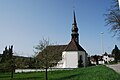
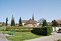
church building in Wolfwil in the canton of Solothurn, Switzerland  | |||||
| Upload media | |||||
| Instance of | |||||
|---|---|---|---|---|---|
| Part of | |||||
| Location | Wolfwil, Gäu District, Thal-Gäu, Solothurn, Switzerland | ||||
| Street address |
| ||||
| Diocese | |||||
| Heritage designation | |||||
 | |||||
Media in category "Church of Wolfwil"
The following 6 files are in this category, out of 6 total.
-
 Wolfwil preghejo 222.JPG 3,872 × 2,592; 4.24 MB
-
 Wolfwil preghejo 229.JPG 3,872 × 2,592; 3.98 MB
-
 Wolfwil preghejo 243.JPG 2,592 × 3,872; 3.71 MB
-
 Wolfwil preghejo 246.JPG 3,872 × 2,592; 4.16 MB
-
 Wolfwil preghejo kaj tombejo 230.JPG 3,872 × 2,592; 4.31 MB
-
 Wolfwil preghejo kaj tombejo 236.JPG 3,872 × 2,592; 4.25 MB


