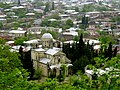
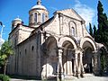
Category:Church of the Annunciation of the Virgin Mary, Kutaisi
| Object location | | View all coordinates using: OpenStreetMap |
|---|
|
This is a category about a monument in Georgia identified by the ID 594
|
cultural heritage monument in Georgia  | |||||
| Upload media | |||||
| Instance of | |||||
|---|---|---|---|---|---|
| Location | Kutaisi, Imereti, Georgia | ||||
| Heritage designation | |||||
 | |||||
Media in category "Church of the Annunciation of the Virgin Mary, Kutaisi"
The following 11 files are in this category, out of 11 total.
-
 Arch of Khareba church.jpg 3,264 × 2,448; 1.58 MB
-
 Catholic Church in Kutaisi (now Georgian Orthodox Church of Annunciation).jpg 2,048 × 1,536; 753 KB
-
 Columns of Khareba church.jpg 2,448 × 3,264; 1.42 MB
-
 Door of Khareba church of Kutaisi.jpg 2,448 × 3,264; 1.6 MB
-
 Georgia 2011 134 (5681277526).jpg 1,220 × 667; 180 KB
-
 Georgia 2011 138 (5680714875).jpg 1,220 × 810; 299 KB
-
 Georgia 2011 172 (5681340608).jpg 1,220 × 915; 264 KB
-
 Khareba church of Kutaisi.jpg 3,264 × 2,448; 1.97 MB
-
 Khareba church.jpg 3,264 × 2,448; 1.71 MB
-
 Kutaisi Church of Annunciation.jpg 2,851 × 2,789; 2.97 MB
-
 ქუთაისის ღვთისმშობლის ხარების ეკლესია.jpg 330 × 341; 19 KB

.jpg)


.jpg)
.jpg)
.jpg)


