Category:Church of the Good Shepherd, Croxteth
| Object location | | View all coordinates using: OpenStreetMap |
|---|
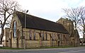
Anglican church in Croxteth, Liverpool, Merseyside UK  | |||||
| Upload media | |||||
| Instance of | |||||
|---|---|---|---|---|---|
| Dedicated to | |||||
| Location | Liverpool, Merseyside, North West England, England | ||||
| Diocese | |||||
| Inception |
| ||||
| Religion or worldview | |||||
 | |||||
Media in category "Church of the Good Shepherd, Croxteth"
The following 12 files are in this category, out of 12 total.
-
 Church of the Good Shepherd, Croxteth (1).JPG 4,320 × 3,240; 4.26 MB
-
 Church of the Good Shepherd, Croxteth (2).JPG 4,320 × 3,240; 3.47 MB
-
 Church of the Good Shepherd, Croxteth 1.jpg 4,867 × 3,059; 18.12 MB
-
 Church of the Good Shepherd, Croxteth 2.jpg 4,741 × 2,972; 19.07 MB
-
 Church of the Good Shepherd, Croxteth 3.jpg 4,840 × 3,365; 23.96 MB
-

-
 Dedication stone, Church of the Good Shepherd, Croxteth.jpg 4,627 × 3,161; 17.72 MB
-
 East end, Church of the Good Shepherd, Croxteth.jpg 4,429 × 3,412; 17.76 MB
-
 Hall, Church of the Good Shepherd, Croxteth.jpg 4,768 × 3,431; 20.87 MB
-
 Porch, Church of the Good Shepherd, Croxteth.jpg 3,381 × 5,152; 19.9 MB
-
 Tower, Church of the Good Shepherd, Croxteth.jpg 3,168 × 4,631; 19.5 MB
-
 West end, Church of the Good Shepherd, Croxteth.jpg 4,542 × 3,414; 21.31 MB
.JPG)
.JPG)


