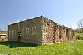
Category:Church of the Pokrov in Płonna
| Object location | | View all coordinates using: OpenStreetMap |
|---|
 | |||||
| Upload media | |||||
| Instance of | |||||
|---|---|---|---|---|---|
| Location | Płonna, Podkarpackie Voivodeship, Gmina Bukowsko, Sanok County, Subcarpathian Voivodeship, Poland | ||||
| Heritage designation |
| ||||
 | |||||
Polski: Płonna - ruiny cerkwi greckokatolickiej p.w. Opieki Najświętszej Marii Panny, trójarkadowa dzwonnica parawanowa, mur kamienny wokół dawnej cerkwi
Media in category "Church of the Pokrov in Płonna"
The following 20 files are in this category, out of 20 total.
-
 08990 Plonna, 2011.jpg 800 × 600; 374 KB
-
 Płonna - cerkiew01.jpg 4,000 × 3,000; 4.01 MB
-
 Płonna - cerkiew04.jpg 4,000 × 3,000; 4.17 MB
-
 01852 2021-02-26 (18) Dorf Plonna in Galizien Sanoker Kreis.png 984 × 618; 1.22 MB
-
 08988 Plonna, 2011.jpg 800 × 600; 469 KB
-
 1. Militärische Aufnahme (-1787) Plonna.JPG 1,024 × 1,192; 646 KB
-
 Płonna - cerkiew05.jpg 3,554 × 2,669; 2.73 MB
-
 Płonna - cerkiew06.jpg 4,000 × 3,000; 3.81 MB
-
 Płonna - cerkiew02.jpg 4,000 × 3,000; 3.81 MB
-
 Płonna Ruiny Cerkwi DZolopa 2021-07-15 143036 0409.jpg 1,408 × 2,112; 2.16 MB
-
 Płonna Ruiny Cerkwi DZolopa 2021-07-15 143505 0412.jpg 2,112 × 1,408; 2.14 MB
-
 Płonna Ruiny Cerkwi DZolopa 2021-07-15 145141 0415.jpg 4,104 × 2,736; 2.16 MB
-
 Płonna, cerkiew Opieki Matki Bożej (HB1).jpg 3,504 × 2,463; 7.18 MB
-
 Płonna, cerkiew Opieki Matki Bożej (HB2).jpg 3,354 × 2,305; 6.04 MB
-
 Płonna, cerkiew Opieki Matki Bożej (HB3).jpg 2,822 × 2,385; 5.28 MB
-
 Płonna, cerkiew Opieki Matki Bożej (HB4).jpg 3,685 × 2,372; 7.34 MB
-
 Płonna, cerkiew Opieki Matki Bożej (HB5).jpg 2,589 × 1,726; 3.38 MB
-
 Płonna, cerkiew Opieki Matki Bożej (HB6).jpg 3,356 × 2,237; 4.52 MB
-
 Płonna, cerkiew Opieki Matki Bożej (HB7).jpg 3,194 × 2,129; 3.65 MB
-
 Płonna, cerkiew Opieki Matki Bożej (HB8).jpg 3,401 × 2,267; 3.92 MB


_Dorf_Plonna_in_Galizien_Sanoker_Kreis.png)

_Plonna.JPG)


.jpg)
.jpg)
.jpg)
.jpg)
.jpg)
.jpg)
.jpg)
.jpg)