Category:Churchyards in Hampshire
Ceremonial counties of England: Bedfordshire · Berkshire · Buckinghamshire · Cambridgeshire · Cheshire · Cornwall · Cumbria · Derbyshire · Devon · Dorset · Durham · East Riding of Yorkshire · East Sussex · Essex · Gloucestershire · Greater London · Greater Manchester · Hampshire · Herefordshire · Hertfordshire · Kent · Lancashire · Leicestershire · Lincolnshire · Merseyside · Norfolk · North Yorkshire · Northamptonshire · Northumberland · Nottinghamshire · Oxfordshire · Rutland · Shropshire · Somerset · South Yorkshire · Staffordshire · Suffolk · Surrey · Tyne and Wear · Warwickshire · West Midlands · West Sussex · West Yorkshire · Wiltshire · Worcestershire
City-counties: Bristol ·
Former historic counties: Middlesex · Sussex ·
Other former counties:
City-counties: Bristol ·
Former historic counties: Middlesex · Sussex ·
Other former counties:
Subcategories
This category has the following 130 subcategories, out of 130 total.
A
- All Saints, Botley (churchyard) (16 F)
C
D
H
- Holy Saviour, Bitterne (12 F)
M
- Mattingley Church (churchyard) (12 F)
O
- All Saints, Odiham (churchyard) (22 F)
P
S
- St George, Damerham (graveyard) (18 F)
- St Luke, Sway (churchyard) (6 F)
- St Mary, Ashley (churchyard) (10 F)
- St Mary, Portsea (churchyard) (13 F)
Media in category "Churchyards in Hampshire"
The following 200 files are in this category, out of 867 total.
(previous page) (next page)-
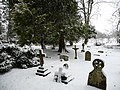
 A chilly Corhampton Churchyard - geograph.org.uk - 1114978.jpg 640 × 480; 95 KB
-

-

-
 A frosty scene in St Faith's Churchyard - geograph.org.uk - 1072434.jpg 640 × 480; 127 KB
-

-

-

-

-
 Abbotts Ann - St Mary's Church - geograph.org.uk - 657627.jpg 640 × 528; 157 KB
-
 Abbotts Ann - War Memorial - geograph.org.uk - 657633.jpg 640 × 512; 171 KB
-
 Snowdrops, Abbotts Ann - geograph.org.uk - 1161258.jpg 640 × 480; 245 KB
-
 St Mary the Virgin, Abbotts Ann - geograph.org.uk - 1505591.jpg 640 × 454; 122 KB
-
-
 Abbotts Ann, parish church of St. Mary - geograph.org.uk - 644496.jpg 640 × 429; 120 KB
-
 All Hallows Church, Whitchurch, Hampshire 11.jpg 3,440 × 3,731; 4.47 MB
-
 All Saints Church Awbridge.jpg 640 × 480; 166 KB
-

-

-

-

-

-
 All Saints Church, Catherington Lane, Catherington (May 2019) (Churchyard) (1).JPG 3,000 × 2,000; 2.6 MB
-
 All Saints Church, Catherington Lane, Catherington (May 2019) (Churchyard) (2).JPG 3,000 × 2,000; 2.64 MB
-
 All Saints Church, Catherington Lane, Catherington (May 2019) (Churchyard) (3).JPG 3,000 × 2,000; 2.75 MB
-

-

-

-

-

-

-

-

-

-

-

-

-

-

-
-

-

-

-

-

-
 All Saints Church, Church Road, Steep (NHLE Code 1351171) (July 2019) (Churchyard).JPG 3,000 × 2,000; 2.18 MB
-

-
 All Saints Church, High Street, Headley (NHLE Code 1094029) (May 2021) (Churchyard).JPG 3,000 × 2,000; 2.79 MB
-
 All Saints Church, Hordle Lane, Hordle (NHLE Code 1221328) (July 2021) (Churchyard) (1).JPG 2,800 × 2,000; 2.79 MB
-
 All Saints Church, Hordle Lane, Hordle (NHLE Code 1221328) (July 2021) (Churchyard) (2).JPG 2,000 × 3,000; 2.89 MB
-
 All Saints Church, Main Road, Hursley (NHLE Code 1095797) (May 2021) (Churchyard) (2).JPG 3,000 × 2,000; 2.65 MB
-
 All Saints Church, Main Road, Hursley (NHLE Code 1095797) (May 2021) (Churchyard) (3).JPG 3,000 × 2,000; 2.65 MB
-
 All Saints Church, Main Road, Hursley (NHLE Code 1095797) (May 2021) (Churchyard) (4).JPG 3,000 × 2,000; 2.61 MB
-
 All Saints Church, Marsh Lane, Fawley (NHLE Code 1351239) (July 2021) (Churchyard) (1).JPG 3,000 × 2,000; 2.64 MB
-
 All Saints Church, Martin, Hampshire (NHLE Code 1094828) (June 2022) (Churchyard) (1).JPG 2,800 × 1,800; 1.95 MB
-

-
-

-

-
-

-
 All Saints churchyard - Deane - geograph.org.uk - 1730892.jpg 640 × 480; 72 KB
-
 All Saints Churchyard - geograph.org.uk - 657915.jpg 640 × 480; 97 KB
-
 All Saints' Church, Crondall 01.jpg 4,000 × 3,000; 3.68 MB
-
 All Saints' Church, Crondall 03.jpg 4,000 × 3,000; 3.37 MB
-
 All Saints' Church, Crondall 138.jpg 4,000 × 3,000; 3.02 MB
-
 All Saints' Church, East Stratton 11.jpg 3,000 × 4,000; 4.1 MB
-
 All Saints' Church, East Stratton 12.jpg 3,000 × 4,000; 5.99 MB
-
 All Saints' Church, East Stratton 13.jpg 3,000 × 4,000; 5.55 MB
-
 All Saints' Church, East Stratton 14.jpg 3,000 × 4,000; 4.97 MB
-
 All Saints' Church, East Stratton 15.jpg 3,000 × 4,000; 3.28 MB
-
 All Saints' Church, East Stratton 16.jpg 3,000 × 4,000; 3.43 MB
-
 All Saints' Church, East Stratton 17.jpg 3,000 × 4,000; 3.34 MB
-
 All Saints' Church, East Stratton 19.jpg 3,000 × 4,000; 4.14 MB
-
 All Saints' churchyard, Barton Stacey 01.jpg 3,000 × 4,000; 4.51 MB
-
 All Saints' churchyard, Barton Stacey 02.jpg 3,000 × 4,000; 6.17 MB
-
 All Saints' churchyard, Barton Stacey 03.jpg 3,000 × 4,000; 5.53 MB
-
 All Saints' churchyard, Barton Stacey 04.jpg 4,000 × 3,000; 5 MB
-
 All Saints' churchyard, Barton Stacey 05.jpg 4,000 × 3,000; 5.85 MB
-
 All Saints' churchyard, Barton Stacey 06.jpg 4,000 × 3,000; 3.91 MB
-
 All Saints' churchyard, Barton Stacey 07.jpg 3,000 × 4,000; 4.76 MB
-
 All Saints' churchyard, Barton Stacey 08.jpg 4,000 × 3,000; 5.9 MB
-
 All Saints' churchyard, Barton Stacey 09.jpg 4,000 × 3,000; 6.14 MB
-
 All Saints' churchyard, Barton Stacey 10.jpg 4,000 × 3,000; 6.87 MB
-
 All Saints' churchyard, Barton Stacey 11.jpg 4,000 × 3,000; 6.63 MB
-
 All Saints' churchyard, Barton Stacey 12.jpg 4,000 × 3,000; 6.02 MB
-
 All Saints' churchyard, Barton Stacey 13.jpg 4,000 × 3,000; 6.28 MB
-
 All Saints' churchyard, Barton Stacey 14.jpg 3,000 × 4,000; 6.62 MB
-
 All Saints' churchyard, Barton Stacey 15.jpg 3,000 × 4,000; 4.94 MB
-
 All Saints' churchyard, Barton Stacey 16.jpg 3,000 × 4,000; 5.82 MB
-
 All Saints' churchyard, Barton Stacey 17.jpg 4,000 × 3,000; 5.52 MB
-
 All Saints' churchyard, Barton Stacey 18.jpg 4,000 × 3,000; 4.85 MB
-
 All Saints' churchyard, Barton Stacey 19.jpg 4,000 × 3,000; 4.56 MB
-
 All Saints' churchyard, Barton Stacey 20.jpg 4,000 × 3,000; 3.31 MB
-
 All Saints' churchyard, Barton Stacey 21.jpg 4,000 × 3,000; 5.55 MB
-
 All Saints' churchyard, Barton Stacey 22.jpg 4,000 × 3,000; 5.18 MB
-
 All Saints' churchyard, Barton Stacey 23.jpg 4,000 × 3,000; 5.2 MB
-
 All Saints' churchyard, Barton Stacey 24.jpg 4,000 × 3,000; 5.05 MB
-
 All Saints' churchyard, Barton Stacey 25.jpg 3,000 × 4,000; 4.42 MB
-

-
 All Shapes and Sizes - geograph.org.uk - 899391.jpg 640 × 467; 110 KB
-
 Amport - Churchyard - geograph.org.uk - 669825.jpg 640 × 480; 151 KB
-
 Amport - Churchyard - geograph.org.uk - 669839.jpg 640 × 480; 174 KB
-

-

-
-
 St James Church Ashmansworth.jpg 640 × 480; 133 KB
-
 Ashmansworth - St James Church - geograph.org.uk - 1204773.jpg 640 × 480; 90 KB
-
 Autumn in St Faith's Churchyard - geograph.org.uk - 1572779.jpg 640 × 480; 86 KB
-
 Barton Stacey - All Saints Church - geograph.org.uk - 1150268.jpg 640 × 480; 59 KB
-
 Barton Stacey - All Saints Church - geograph.org.uk - 1150419.jpg 480 × 640; 86 KB
-
 Barton Stacey - Graveyard - geograph.org.uk - 1150284.jpg 640 × 480; 107 KB
-
 Barton Stacey Parish Church, Hampshire-2Oct2009.jpg 3,264 × 2,448; 1.78 MB
-
-

-
 St Stephen's near Baughurst - geograph.org.uk - 28445.jpg 640 × 480; 162 KB
-

-
 Snow covered tombstones in the churchyard - geograph.org.uk - 752326.jpg 640 × 480; 120 KB
-
 St Peter's Church Beech - geograph.org.uk - 148398.jpg 640 × 480; 165 KB
-
 St Peter, Beech - geograph.org.uk - 1493006.jpg 640 × 416; 121 KB
-
 St Mary's Church, Bentley, Hampshire 17.JPG 4,000 × 3,000; 3.19 MB
-
 Bentley - geograph.org.uk - 4447.jpg 640 × 427; 241 KB
-
 Bentworth church war memorial.jpg 1,117 × 691; 74 KB
-
 St mary's bentworth22.JPG 4,928 × 3,264; 7.12 MB
-
 St Mary's Church, Bentworth (winter).jpg 3,264 × 1,836; 2.34 MB
-
 St Mary's Church, Bentworth 2017.jpg 3,264 × 1,836; 5.1 MB
-
 The war memorial at St Mary, Bentworth (geograph 2174732).jpg 480 × 640; 121 KB
-
 Bentworth churchyard.jpg 3,264 × 1,836; 5.98 MB
-
 Bentworth St. Mary Church.JPG 2,592 × 1,944; 1.35 MB
-
 Holy Cross Parish Church, Binsted, Hampshire.jpg 2,576 × 1,930; 960 KB
-

-

-

-
 Holy Saviour, Bitterne - geograph.org.uk - 1548287.jpg 640 × 447; 75 KB
-
 Blessed Mary Church, Church Street, Upham (NHLE Code 1350596) (May 2021) (Churchyard).JPG 3,008 × 2,000; 2.87 MB
-
 Bluebells in East Tisted Churchyard - geograph.org.uk - 408344.jpg 640 × 480; 190 KB
-

-
 Boldre Church - geograph.org.uk - 43414.jpg 640 × 480; 174 KB
-
 Boldre Church New Forest.jpg 3,264 × 2,448; 1.76 MB
-
 Boundary Wall Of St Thomas' Churchyard.jpg 3,024 × 4,032; 6.04 MB
-
 St Peter's Church, Shakespeare Road - geograph.org.uk - 965418.jpg 640 × 418; 121 KB
-
 All Saints', Bradley - geograph.org.uk - 1556145.jpg 640 × 480; 163 KB
-
 St James - geograph.org.uk - 895946.jpg 480 × 640; 100 KB
-
 Bramshaw, parish church of St. Peter - geograph.org.uk - 644412.jpg 640 × 428; 87 KB
-

-
 Military Cemetery, Bramshott - geograph.org.uk - 1298142.jpg 640 × 480; 140 KB
-
 St Mary, Bramshott - geograph.org.uk - 1493226.jpg 455 × 640; 101 KB
-
 Bramshott Churchyard 01.jpg 4,000 × 3,000; 5.6 MB
-
 Bramshott Churchyard 02.jpg 3,000 × 4,000; 3.13 MB
-
 Bramshott Churchyard 03.jpg 4,000 × 3,000; 4.7 MB
-
 Bramshott Churchyard 04.jpg 4,000 × 3,000; 5.13 MB
-
 Bramshott Churchyard 05.jpg 3,000 × 4,000; 7.5 MB
-
 Bramshott Churchyard 09.jpg 4,000 × 3,000; 4.91 MB
-
 Bramshott Churchyard 10.jpg 3,000 × 4,000; 6.12 MB
-
 Bramshott Churchyard 11.jpg 3,000 × 4,000; 6.07 MB
-
 Bramshott Churchyard 12.jpg 4,000 × 3,000; 4.97 MB
-
 Bramshott Churchyard 13.jpg 4,000 × 3,000; 4.73 MB
-
 Bramshott Churchyard 14.jpg 3,000 × 4,000; 5.87 MB
-
 Bramshott Churchyard 15.jpg 4,000 × 3,000; 5.72 MB
-
 Bramshott Churchyard 16.jpg 4,000 × 3,000; 4.79 MB
-
 Bramshott Churchyard 17.jpg 3,000 × 4,000; 7.32 MB
-
 Bramshott Churchyard 18.jpg 4,000 × 3,000; 6.38 MB
-
 Bramshott Churchyard 19.jpg 4,000 × 3,000; 4.38 MB
-
 Bramshott Churchyard 20.jpg 4,000 × 3,000; 6.72 MB
-
 Bramshott Churchyard 21.jpg 4,000 × 3,000; 4.67 MB
-
 Bramshott Churchyard 22.jpg 4,000 × 3,000; 6.24 MB
-
 Bramshott Churchyard 23.jpg 4,000 × 3,000; 5.83 MB
-
 Bramshott Churchyard 24.jpg 4,000 × 3,000; 3.39 MB
-
 Bramshott Churchyard 25.jpg 4,000 × 3,000; 5.82 MB
-
 Bramshott Churchyard 26.jpg 4,000 × 3,000; 5.5 MB
-
 Bramshott Churchyard 27.jpg 4,000 × 3,000; 4 MB
-
 Bramshott Manor from Bramshott churchyard.jpg 4,000 × 3,000; 4.08 MB
-
 Bramshott Military Cemetery - geograph.org.uk - 1298163.jpg 640 × 480; 130 KB
-
 St Mary's Church, Breamore - geograph.org.uk - 25419.jpg 640 × 480; 439 KB
-

-

-
 St Saviour's Church, Brockenhurst - geograph.org.uk - 171691.jpg 640 × 436; 160 KB
-
 Broughton - Graveyard Of St Marys Church - geograph.org.uk - 755833.jpg 640 × 480; 121 KB
-
 Broughton Dovecote.jpg 3,648 × 2,736; 5 MB
-

-
 St Mary the Virgin, Buriton - geograph.org.uk - 1493240.jpg 640 × 475; 104 KB
-

-
 Canada Common Methodist Church, Canada Common, near West Wellow (July 2021) (Churchyard).jpg 3,000 × 2,000; 2.87 MB
-
 Cathedral churchyard - geograph.org.uk - 1634322.jpg 640 × 426; 176 KB
-
 Cathedral churchyard, west end - geograph.org.uk - 1634298.jpg 640 × 426; 205 KB
-
 Cathedral Green - geograph.org.uk - 1162811.jpg 640 × 477; 105 KB
-
 St Nicholas' church - geograph.org.uk - 1225594.jpg 640 × 480; 169 KB
-
 St Nicholas' church - geograph.org.uk - 1225596.jpg 640 × 503; 199 KB
-
 St Nicholas' church - geograph.org.uk - 1225600.jpg 640 × 480; 185 KB
-
 St Nicholas' churchyard - geograph.org.uk - 1225584.jpg 640 × 479; 166 KB
-
 St Nicholas' churchyard - geograph.org.uk - 1225590.jpg 640 × 512; 163 KB
-
 St Nicholas' churchyard - geograph.org.uk - 1225663.jpg 640 × 480; 192 KB
-
 Christ Church, Deerleap Lane, Colbury (NHLE Code 1094343) (June 2022) (Churchyard).JPG 3,000 × 2,000; 2.53 MB
-
 Christ Church, Emery Down, near Lyndhurst (NHLE Code 1094721) (July 2021) (Churchyard).JPG 3,000 × 2,000; 3.01 MB
-

-
 Christ Church, Smannell Road, Smannell (NHLE Code 1236575) (July 2022) (Churchyard).jpg 3,000 × 2,000; 2.18 MB
-

-
 Church of Our Lady, Warnford 04.jpg 5,152 × 3,864; 4.44 MB
-
 Church of Our Lady, Warnford 05.jpg 5,152 × 3,864; 4.46 MB
-
 Church of St Andrew, Kilmeston - geograph.org.uk - 438365.jpg 640 × 509; 235 KB
-
 Church of St Peter, Bishop's Waltham - geograph.org.uk - 225881.jpg 478 × 640; 158 KB


_(July_2021)_(Churchyard)_(1).JPG)
_(July_2021)_(Churchyard)_(2).JPG)
_(July_2021)_(Churchyard)_(3).JPG)
_(June_2022)_(Churchyard)_(1).JPG)
_(June_2022)_(Churchyard)_(2).JPG)
_(Churchyard)_(1).JPG)
_(Churchyard)_(2).JPG)
_(Churchyard)_(3).JPG)
_(July_2021)_(Churchyard)_(1).JPG)
_(July_2021)_(Churchyard)_(2).JPG)
_(July_2021)_(Churchyard)_(3).JPG)
_(July_2021)_(Churchyard)_(1).jpg)
_(July_2021)_(Churchyard)_(2).jpg)
_(May_2021)_(Churchyard)_(1).jpg)
_(May_2021)_(Churchyard)_(2).jpg)
_(May_2021)_(Churchyard)_(1).jpg)
_(May_2021)_(Churchyard)_(2).jpg)
_(May_2021)_(Wellhouse).jpg)
_(July_2021)_(Churchyard)_(1).JPG)
_(July_2021)_(Churchyard)_(2).JPG)
_(July_2022)_(Churchyard)_(1).jpg)
_(July_2022)_(Churchyard)_(2).jpg)
_(July_2022)_(Churchyard)_(3).jpg)
_(May_2021)_(Churchyard)_(1).JPG)
_(May_2021)_(Churchyard)_(2).JPG)
_(May_2021)_(Churchyard)_(3).JPG)
_(May_2021)_(Churchyard)_(4).JPG)
_(May_2021)_(Churchyard)_(5).JPG)
_(July_2019)_(Churchyard).JPG)
_(June_2019)_(Churchyard).JPG)
_(May_2021)_(Churchyard).JPG)
_(July_2021)_(Churchyard)_(1).JPG)
_(July_2021)_(Churchyard)_(2).JPG)
_(May_2021)_(Churchyard)_(2).JPG)
_(May_2021)_(Churchyard)_(3).JPG)
_(May_2021)_(Churchyard)_(4).JPG)
_(July_2021)_(Churchyard)_(1).JPG)
_(June_2022)_(Churchyard)_(1).JPG)
_(June_2022)_(Churchyard)_(2).JPG)

_(May_2021)_(Churchyard).JPG)
_(July_2022)_(Churchyard)_(1).jpg)
_(July_2022)_(Churchyard)_(2).jpg)
_(July_2022)_(Churchyard)_(3).jpg)


.jpg)

.jpg)


_(May_2021)_(Churchyard).JPG)


.jpg)


_(May_2021).JPG)
_(Churchyard).jpg)


_(June_2022)_(Churchyard).JPG)
_(July_2021)_(Churchyard).JPG)
_(July_2022)_(Churchyard).jpg)
_(July_2022)_(Churchyard).jpg)
_(Churchyard).JPG)


