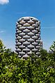
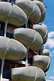
Category:Cité des Choux-Fleurs
| Object location | | View all coordinates using: OpenStreetMap |
|---|
|
This building is indexed in the base Mérimée, a database of architectural heritage maintained by the French Ministry of Culture, under the reference EA94000002
|
Group of buildings in Paris, France .jpg) | |||||
| Upload media | |||||
| Instance of |
| ||||
|---|---|---|---|---|---|
| Location | Créteil, Val-de-Marne, Île-de-France, Metropolitan France, France | ||||
| Located on street | |||||
| Architect |
| ||||
| Heritage designation | |||||
 | |||||
Media in category "Cité des Choux-Fleurs"
The following 16 files are in this category, out of 16 total.
-
 Créteil Choux de Créteil 618.jpg 4,896 × 3,264; 10.98 MB
-
 Créteil Choux de Créteil 619.jpg 4,896 × 3,264; 13.01 MB
-
 Créteil hiver.jpg 1,931 × 1,259; 542 KB
-
 Les Choux de Créteil - panoramio (1).jpg 1,356 × 2,048; 798 KB
-
 Les Choux de Créteil - panoramio (10).jpg 1,356 × 2,048; 607 KB
-
 Les Choux de Créteil - panoramio (11).jpg 1,356 × 2,048; 588 KB
-
 Les Choux de Créteil - panoramio (2).jpg 1,356 × 2,048; 626 KB
-
 Les Choux de Créteil - panoramio (3).jpg 2,048 × 1,356; 836 KB
-
 Les Choux de Créteil - panoramio (4).jpg 1,356 × 2,048; 477 KB
-
 Les Choux de Créteil - panoramio (5).jpg 1,356 × 2,048; 569 KB
-
 Les Choux de Créteil - panoramio (6).jpg 2,048 × 1,356; 807 KB
-
 Les Choux de Créteil - panoramio (7).jpg 1,356 × 2,048; 669 KB
-
 Les Choux de Créteil - panoramio (8).jpg 1,356 × 2,048; 721 KB
-
 Les Choux de Créteil - panoramio (9).jpg 1,356 × 2,048; 545 KB
-
 Les Choux de Créteil - panoramio.jpg 2,048 × 1,356; 842 KB
-
 What you can see at Boulevard Pablo Picasso - panoramio.jpg 2,560 × 1,920; 2.34 MB


.jpg)
.jpg)
.jpg)
.jpg)
.jpg)
.jpg)
.jpg)
.jpg)
.jpg)
.jpg)

