Category:City limit signs in Manche
Departments of Metropolitan France: Ain [01] · Aisne [02] · Allier [03] · Alpes-de-Haute-Provence [04] · Hautes-Alpes [05] · Alpes-Maritimes [06] · Ardèche [07] · Ardennes [08] · Ariège [09] · Aube [10] · Aude [11] · Aveyron [12] · Bouches-du-Rhône [13] · Calvados [14] · Cantal [15] · Charente [16] · Charente-Maritime [17] · Cher [18] · Corrèze [19] · Corse-du-Sud [2A]† · Haute-Corse [2B]† · Côte-d’Or [21] · Côtes-d'Armor [22] · Creuse [23] · Dordogne [24] · Doubs [25] · Drôme [26] · Eure [27] · Eure-et-Loir [28] · Finistère [29] · Gard [30] · Haute-Garonne [31] · Gers [32] · Gironde [33] · Hérault [34] · Ille-et-Vilaine [35] · Indre [36] · Indre-et-Loire [37] · Isère [38] · Jura [39] · Landes [40] · Loir-et-Cher [41] · Loire [42] · Haute-Loire [43] · Loire-Atlantique [44] · Loiret [45] · Lot [46] · Lot-et-Garonne [47] · Lozère [48] · Maine-et-Loire [49] · Manche [50] · Marne [51] · Haute-Marne [52] · Mayenne [53] · Meurthe-et-Moselle [54] · Meuse [55] · Morbihan [56] · Moselle [57] · Nièvre [58] · Nord [59] · Oise [60] · Orne [61] · Pas-de-Calais [62] · Puy-de-Dôme [63] · Pyrénées-Atlantiques [64] · Hautes-Pyrénées [65] · Pyrénées-Orientales [66] · Bas-Rhin [67] · Haut-Rhin [68] · departmental district of the Rhône [69] · Haute-Saône [70] · Saône-et-Loire [71] · Sarthe [72] · Savoie [73] · Haute-Savoie [74] · Paris [75] · Seine-Maritime [76] · Seine-et-Marne [77] · Yvelines [78] · Deux-Sèvres [79] · Somme [80] · Tarn [81] · Var [83] · Vaucluse [84] · Vendée [85] · Vienne [86] · Haute-Vienne [87] · Vosges [88] · Yonne [89] · Territoire de Belfort [90] · Essonne [91] · Hauts-de-Seine [92] · Seine-Saint-Denis [93] · Val-de-Marne [94] · Val-d'Oise [95]
Media in category "City limit signs in Manche"
The following 35 files are in this category, out of 35 total.
-
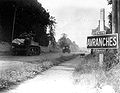
 American tanks move through Avranches.jpg 1,592 × 1,240; 281 KB
-
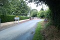
 Avranches 1.jpg 796 × 620; 171 KB
-
 Beuvrigny.jpg 2,592 × 1,728; 1.43 MB
-
 Biville (Manche) entrée de La Croix Frimot.jpg 3,648 × 2,736; 4.23 MB
-
 Biville (Manche) entrée du bourg.jpg 2,736 × 3,648; 1.86 MB
-
 Commune de SAINT-JEAN-DE-SAVIGNY.jpg 3,456 × 2,304; 1.53 MB
-
 Ecoqueneauville.JPG 3,072 × 2,304; 2.58 MB
-
 Entrée commune de Cerisy-La-Forêt.png 1,385 × 1,039; 3.11 MB
-
 Entrée de bourg.jpg 4,000 × 3,000; 3.59 MB
-
 Entrée de Saint-André-de-l'Épine.jpg 2,592 × 1,728; 1.93 MB
-
 Fourneaux, Manche.jpg 2,592 × 1,728; 1.54 MB
-
 FranceNormandieSaintMichelDeMontjoiePanneau.jpg 1,373 × 1,830; 2.55 MB
-
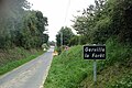 Gerville-la-Forêt - Panneau d'entrée.jpg 2,592 × 1,728; 2.06 MB
-
 Grimesnil.JPG 4,000 × 3,000; 2.11 MB
-
 La Chapelle-du-Fest - entrée de la commune.jpg 2,592 × 1,728; 1.35 MB
-
 La Chapelle-sur-Vire.jpg 2,592 × 1,728; 1.69 MB
-
 La Fresnerie.jpg 448 × 300; 25 KB
-
 La Gohannière - Entrée du bourg.JPG 4,000 × 3,000; 2.8 MB
-
 Le Hommet-d'Arthenay.JPG 4,320 × 3,240; 2.99 MB
-
 Le Mesnil-Amand.JPG 4,000 × 3,000; 2.38 MB
-
 Le Mesnil-Amey - Entrée du bourg.jpg 2,592 × 1,728; 1.49 MB
-
 Le Perron.jpg 2,592 × 1,728; 1.35 MB
-
 Le Tanu.JPG 4,000 × 3,000; 2.17 MB
-
 Les Chéris.JPG 4,000 × 3,000; 2.41 MB
-
 Les Pieux (Manche) city limit sign.jpg 3,648 × 2,736; 3.98 MB
-
 Neuville-en-Beaumont.jpg 2,592 × 1,728; 1.46 MB
-
 Panneau signalétique de la commune Hauteville-sur-Mer.png 606 × 848; 435 KB
-
 Pont de Saint-Fromond - vers Airel.jpg 2,592 × 1,728; 1.75 MB
-
 Pont de Saint-Fromond - vers Saint-Fromond.jpg 2,592 × 1,728; 1.12 MB
-
 Pont-Hébert - Vue sur le bourg.jpg 2,592 × 1,728; 1.32 MB
-
 Rauville-la-Bigot - Vue générale du bourg.JPG 5,184 × 3,456; 7.14 MB
-
 Saint-Georges-de-Bohon - Mairie.jpg 2,592 × 1,728; 1.22 MB
-
 Saint-Georges-de-Livoye.JPG 4,000 × 3,000; 1.9 MB
-
 Siouville-Hague (Manche) city limit sign.jpg 3,648 × 2,736; 4.04 MB
-
 Tonneville (50).jpg 4,608 × 3,456; 6.41 MB


_entr%C3%A9e_de_La_Croix_Frimot.jpg)
_entr%C3%A9e_du_bourg.jpg)


_city_limit_sign.jpg)


_city_limit_sign.jpg)
.jpg)