Category:Claife Station
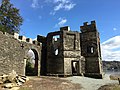
Claife Station, an 18th century folly and view lookout, below Claife Heights on the western shore of Windermere, facing Bowness in the Lake District of North-West England.
These "stations" were viewpoints where tourists could enjoy the best views of the landscape, being encouraged to appreciated the formal qualities of the landscape and to apply aesthetic values. At some of these stations, buildings were erected to help this process. Claife Station was built in the 1790s.
The windows of the drawing room were the Station's most celebrated feature; each had a different aspect, viewed through different coloured glass to enhance variations in weather and seasons. The tinted glass in these windows was intended to recreate lighting effects in the landscape. Yellow represented summer, orange was for autumn, light green for spring, and light blue for winter. There was also a dark blue for moonlight and a lilac tint to give the impression of a thunderstorm. Tourists were encouraged furthermore to look at the views through a Claude glass, a mirror which framed the landscape and allowed it to be more picturesque, literally more like a picture.
This picturesque way of viewing the landscape was further popularised by books by the Reverend William Gilpin including Observations, relative chiefly to picturesque beauty, made in the year 1772, on several parts of England; particularly the mountains, and lakes of Cumberland, and Westmoreland published in 1786, and Three essays: on picturesque beauty; on picturesque travel; and on sketching landscape (1792).
Now owned by the National Trust as part of their Hawkshead and Claife property.
This is a category about listed building number 1087305. |
building in Claife, South Lakeland, Cumbria, UK  | |||||
| Upload media | |||||
| Instance of | |||||
|---|---|---|---|---|---|
| Location | Claife, Westmorland and Furness, Cumbria, North West England, England | ||||
| Heritage designation |
| ||||
| Different from | |||||
 | |||||
Media in category "Claife Station"
The following 11 files are in this category, out of 11 total.
-

-
 Buildings by Windermere (6700).jpg 4,288 × 2,848; 6.4 MB
-
 Claife Station - geograph.org.uk - 2750603.jpg 640 × 480; 108 KB
-
 Claife Station - geograph.org.uk - 2784505.jpg 1,600 × 1,200; 658 KB
-
 Claife Station - geograph.org.uk - 3982292.jpg 1,000 × 1,000; 377 KB
-
 Claife Station.jpg 800 × 600; 214 KB
-
 Claife Viewing Station - geograph.org.uk - 3982307.jpg 1,000 × 750; 473 KB
-
 Claife Viewing Station - geograph.org.uk - 5955736.jpg 465 × 640; 142 KB
-

-
 Claife Viewing Station.jpg 3,264 × 2,448; 3.08 MB
-
 The Lakes (8729039608).jpg 2,500 × 1,667; 1.54 MB

.jpg)


.jpg)