Category:Clyne and Melincourt
community in Neath Port Talbot | |||||
| Upload media | |||||
| Instance of | |||||
|---|---|---|---|---|---|
| Location | Neath Port Talbot, Wales | ||||
| Population |
| ||||
| Area |
| ||||
 | |||||
Subcategories
This category has the following 2 subcategories, out of 2 total.
C
- Clyne, Neath Port Talbot (19 F)
M
Media in category "Clyne and Melincourt"
The following 200 files are in this category, out of 204 total.
(previous page) (next page)-
 20 on the B4434 Lletty Dafydd, Clyne - geograph.org.uk - 4928374.jpg 800 × 708; 124 KB
-
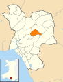
 2010 Wales Neath Port Talbot Community Clyne and Melincourt map.svg 512 × 666; 423 KB
-
 2024 Wales Neath Port Talbot Community Clyne and Melincourt map.svg 512 × 666; 548 KB
-
 Access road to Ty Du Farm, Clyne - geograph.org.uk - 5200040.jpg 800 × 600; 170 KB
-

-
 Afan Forest Park - geograph.org.uk - 5687317.jpg 2,392 × 3,189; 2.1 MB
-
 Ancient track - geograph.org.uk - 6176712.jpg 3,239 × 2,430; 4.14 MB
-
 B4434 crossing rusted railway bridge near Clyne - geograph.org.uk - 5895278.jpg 1,024 × 696; 177 KB
-
 B4434 Underbridge name, Clyne - geograph.org.uk - 6427833.jpg 640 × 473; 110 KB
-
 Banwen Torybetel - geograph.org.uk - 5687221.jpg 2,448 × 3,264; 2.23 MB
-
 Bend in the B4434, Clyne - geograph.org.uk - 6345803.jpg 1,600 × 1,333; 557 KB
-
 Beware - Oncoming Buses in Middle of Road, Clyne - geograph.org.uk - 6427845.jpg 1,600 × 1,283; 523 KB
-
 Bilingual name sign on the east side of the B4434, Clyne - geograph.org.uk - 6427841.jpg 1,382 × 1,600; 733 KB
-
 Blaen Cwm Caca - geograph.org.uk - 5421313.jpg 2,155 × 2,870; 1.61 MB
-
 Blaen Cwm Caca - geograph.org.uk - 5421376.jpg 3,264 × 2,448; 2.79 MB
-
 Blaen Cwmbach Farm - geograph.org.uk - 5687320.jpg 3,264 × 2,448; 2.2 MB
-
 Blue van in Clyne - geograph.org.uk - 5199865.jpg 800 × 712; 153 KB
-
 Boundary wall - geograph.org.uk - 6177385.jpg 3,169 × 2,377; 2.93 MB
-
 Boundary wall - geograph.org.uk - 6177392.jpg 2,048 × 1,536; 1.37 MB
-
 Bryn Golwg, Clyne - geograph.org.uk - 6340991.jpg 1,600 × 1,104; 296 KB
-

-

-

-
 Bus shelter detail, Clyne - geograph.org.uk - 6340510.jpg 994 × 1,024; 399 KB
-
 Bus shelter on the east side of the B4434, Clyne - geograph.org.uk - 6340504.jpg 1,435 × 1,600; 532 KB
-

-
 Canal Lock at Clyne - geograph.org.uk - 4785843.jpg 2,448 × 3,264; 2.7 MB
-
 Canal Lock Gate - geograph.org.uk - 4785848.jpg 3,264 × 2,448; 3.03 MB
-
 Canal Viaduct - geograph.org.uk - 4785862.jpg 2,448 × 3,264; 2.3 MB
-
 Canal view - geograph.org.uk - 5501889.jpg 3,264 × 2,448; 2.23 MB
-
 Carn Caca - geograph.org.uk - 4033607.jpg 640 × 480; 95 KB
-
 Cefn Ffordd - geograph.org.uk - 4033620.jpg 640 × 480; 76 KB
-
 Celtic Trail marker post - geograph.org.uk - 5687218.jpg 2,448 × 3,264; 2.92 MB
-
 Church information board, Clyne - geograph.org.uk - 4928321.jpg 635 × 800; 205 KB
-
 Clun Isaf Lock - geograph.org.uk - 5499825.jpg 4,000 × 3,000; 3.25 MB
-
 Clun Primary School (Clyne) - geograph.org.uk - 5256161.jpg 3,264 × 2,448; 1.86 MB
-
 Clun Primary School, Clyne - geograph.org.uk - 4928204.jpg 800 × 602; 146 KB
-
 Clun Uchaf Lock - geograph.org.uk - 5499816.jpg 4,000 × 3,000; 4.23 MB
-
 Clyne Community Hall - geograph.org.uk - 6340421.jpg 1,600 × 1,216; 329 KB
-
 Clyne Sewage Pumping Station - geograph.org.uk - 6345837.jpg 1,600 × 1,107; 524 KB
-
 Clyne Terrace, Clyne - geograph.org.uk - 6345099.jpg 1,543 × 1,600; 504 KB
-
 Coal Tip - geograph.org.uk - 5421404.jpg 3,264 × 2,448; 2.4 MB
-
 Coedwigoedd Pelenna - Pelenna Forestry - geograph.org.uk - 5260579.jpg 640 × 480; 137 KB
-

-
 Cycle lane at the edge of the B4434, Clyne - geograph.org.uk - 6345829.jpg 1,014 × 1,024; 389 KB
-
 Dan yr A465 - Under the A465 - geograph.org.uk - 4524817.jpg 640 × 480; 107 KB
-
 Derelict house alongside the B4434, Clyne - geograph.org.uk - 6340979.jpg 1,600 × 1,592; 543 KB
-
 Descent towards a railway bridge, Clyne - geograph.org.uk - 6427839.jpg 1,600 × 1,015; 626 KB
-
 Dunvant Avenue, Clyne - geograph.org.uk - 5199950.jpg 797 × 800; 310 KB
-
 East along the B4434, Clyne - geograph.org.uk - 5371399.jpg 800 × 708; 139 KB
-
 End of the 30 zone south of Clyne - geograph.org.uk - 6427925.jpg 1,536 × 1,498; 718 KB
-
 Energy landscape - geograph.org.uk - 6177165.jpg 2,048 × 1,536; 1.05 MB
-
 Entrance to Halt House, Clyne - geograph.org.uk - 6345090.jpg 1,024 × 964; 372 KB
-
 Evangelical Church - geograph.org.uk - 5256144.jpg 3,264 × 2,448; 2.39 MB
-
 Fallen tree - geograph.org.uk - 6177211.jpg 2,048 × 1,536; 1.81 MB
-
 Farm access road, Clyne - geograph.org.uk - 6345816.jpg 1,600 × 1,200; 718 KB
-
 Farm buildings at the southern edge of Clyne - geograph.org.uk - 6427865.jpg 1,600 × 1,042; 577 KB
-
 Farm buildings, Clyne - geograph.org.uk - 6427854.jpg 1,600 × 1,082; 498 KB
-
 Ffarm Clun - Clyne Farm - geograph.org.uk - 5260629.jpg 640 × 480; 68 KB
-
 Ffarm Ystrad Owen - Ystrad Owen Farm - geograph.org.uk - 5260609.jpg 640 × 480; 94 KB
-
 Ffynnon Oer - geograph.org.uk - 5421506.jpg 3,264 × 2,448; 3.57 MB
-
 Footbridge across the Neath Canal - geograph.org.uk - 5499795.jpg 4,000 × 3,000; 4.24 MB
-
 Footbridge in Melincourt Valley - geograph.org.uk - 5421279.jpg 3,264 × 2,448; 3.25 MB
-
 Footbridge over a railway, Clyne - geograph.org.uk - 5371296.jpg 800 × 600; 180 KB
-
 Footpath and cycle route above the Neath Canal, Clyne - geograph.org.uk - 6428107.jpg 1,511 × 1,600; 965 KB
-
 Forest path - geograph.org.uk - 6177217.jpg 1,536 × 2,048; 1.66 MB
-
 Former shop in Clyne - geograph.org.uk - 6340987.jpg 1,132 × 1,402; 560 KB
-
 Frog spawn - geograph.org.uk - 5687315.jpg 3,264 × 2,448; 2.96 MB
-
 From 20 to 30 on the B4434, Clyne - geograph.org.uk - 5371343.jpg 719 × 800; 159 KB
-

-
 From 30 to 20 on the B4434, Clyne - geograph.org.uk - 5371326.jpg 800 × 620; 137 KB
-
 From Clyne to Melincourt - geograph.org.uk - 5199632.jpg 800 × 665; 186 KB
-
 Gas installation, Clyne - geograph.org.uk - 6345037.jpg 1,363 × 1,600; 539 KB
-
 Gas pipe marker - geograph.org.uk - 5687314.jpg 2,448 × 3,264; 2.64 MB
-
 Gas pipeline markers alongside the B4434 near Clyne - geograph.org.uk - 6428052.jpg 1,600 × 1,200; 703 KB
-

-

-
 Ger Blaen Twrch - Near Blaen Twrch - geograph.org.uk - 5260614.jpg 480 × 640; 129 KB
-
 Gored Terrace, Melincourt - geograph.org.uk - 5199836.jpg 800 × 600; 109 KB
-
 Heol Nant houses, Clyne - geograph.org.uk - 6345087.jpg 1,600 × 1,200; 483 KB
-
 Hermon Chapel - geograph.org.uk - 4097887.jpg 640 × 480; 59 KB
-
 Hermon Chapel nameboard, Clyne - geograph.org.uk - 6345686.jpg 1,530 × 1,600; 605 KB
-
 Hermon Chapel, Clyne - geograph.org.uk - 6345683.jpg 1,600 × 1,311; 400 KB
-
 Hillside public footpath, Melincourt - geograph.org.uk - 5199843.jpg 800 × 600; 170 KB
-

-
 Houses and cars on the east side of the B4434, Clyne - geograph.org.uk - 6340976.jpg 1,600 × 1,515; 489 KB
-
 Houses and cars on the north side of the B4434, Clyne - geograph.org.uk - 6345690.jpg 1,600 × 1,179; 302 KB
-
 Houses on the east side of Bryn Golwg, Clyne - geograph.org.uk - 6341005.jpg 1,600 × 1,277; 407 KB
-
 Houses on the north side of the B4434, Clyne - geograph.org.uk - 6340994.jpg 1,600 × 1,340; 412 KB
-
 Houses, tree and cars, Ynys yr Afon, Clyne - geograph.org.uk - 6340443.jpg 1,155 × 1,380; 428 KB
-
 Inconspicuous boundary sign, Clyne - geograph.org.uk - 5199851.jpg 800 × 700; 150 KB
-

-

-

-
 Level crossing gate, Clyne - geograph.org.uk - 6345084.jpg 1,600 × 1,319; 553 KB
-
 Level crossing in Clyne - geograph.org.uk - 6345048.jpg 1,600 × 1,200; 569 KB
-
 Line spur pole, Clyne - geograph.org.uk - 6345094.jpg 1,600 × 1,567; 521 KB
-

-
 Lletty Dafydd houses, Clyne - geograph.org.uk - 5199916.jpg 800 × 548; 123 KB
-

-

-

-
 Llys Dyfnant scaffolding, Clyne - geograph.org.uk - 5199872.jpg 800 × 600; 168 KB
-
 Llys Dyfnant, Clyne - geograph.org.uk - 5199907.jpg 800 × 671; 180 KB
-
 Lock gate mechanism - geograph.org.uk - 4785855.jpg 2,448 × 3,264; 2.51 MB
-
 Lock on Neath Canal at Clyne - geograph.org.uk - 4467676.jpg 1,456 × 2,592; 1.53 MB
-
 Maes Pwll bungalows, Clyne - geograph.org.uk - 5371359.jpg 800 × 443; 83 KB
-
 Maes Pwll houses, Clyne - geograph.org.uk - 5371365.jpg 800 × 637; 118 KB
-
 Magical Woodland - geograph.org.uk - 5686904.jpg 3,264 × 2,448; 3.9 MB
-
 Melin Court Waterfall - geograph.org.uk - 3788644.jpg 640 × 480; 55 KB
-
 Melincourt Tributary - geograph.org.uk - 5421386.jpg 2,056 × 2,741; 1.91 MB
-
 Mile Stone Resolven 1 - geograph.org.uk - 4097852.jpg 480 × 640; 110 KB
-
 Modern houses, Clyne - geograph.org.uk - 5199985.jpg 800 × 542; 110 KB
-
 Modern houses, Lletty Dafydd, Clyne - geograph.org.uk - 5199989.jpg 800 × 472; 96 KB
-
 Muddy outfall above the B4434 New Road, Clyne - geograph.org.uk - 6427850.jpg 1,392 × 1,600; 804 KB
-
 Muddy Track - geograph.org.uk - 5421307.jpg 2,448 × 3,264; 3.52 MB
-
 Neath Canal - geograph.org.uk - 4467667.jpg 2,592 × 1,456; 1.56 MB
-
 Neath Road heads out of Resolven - geograph.org.uk - 2539683.jpg 640 × 479; 63 KB
-
 New waymarker for bridleway and footpath - geograph.org.uk - 6177365.jpg 2,900 × 2,174; 2.08 MB
-
 North side of a railway bridge, Clyne - geograph.org.uk - 6427783.jpg 1,469 × 1,600; 608 KB
-
 North through a level crossing, Clyne - geograph.org.uk - 6345089.jpg 1,600 × 1,200; 534 KB
-
 Ordnance Survey Cut Mark - geograph.org.uk - 4097849.jpg 480 × 640; 119 KB
-
 Ordnance Survey Cut Mark - geograph.org.uk - 4097859.jpg 480 × 640; 125 KB
-
 Ordnance Survey Cut Mark - geograph.org.uk - 4097865.jpg 480 × 640; 71 KB
-
 Ordnance Survey Cut Mark - geograph.org.uk - 4097876.jpg 480 × 640; 123 KB
-
 Ordnance Survey Cut Mark - geograph.org.uk - 4097883.jpg 480 × 640; 104 KB
-
 Ordnance Survey Cut Mark - geograph.org.uk - 4097896.jpg 480 × 640; 108 KB
-
 Ordnance Survey Cut Mark - geograph.org.uk - 4097903.jpg 480 × 640; 129 KB
-
 Parallel railway bridges, Clyne - geograph.org.uk - 5371289.jpg 800 × 708; 196 KB
-
 Pen Rhiw Angharad Uchaf - geograph.org.uk - 5687325.jpg 3,264 × 2,448; 2.27 MB
-
 Phonebox and postbox, Bryn Golwg, Clyne - geograph.org.uk - 6340998.jpg 1,024 × 975; 190 KB
-
 Public footpath near Ty Du Farm, Clyne - geograph.org.uk - 5200054.jpg 800 × 600; 234 KB
-

-
 Public footpath, Clyne - geograph.org.uk - 6345703.jpg 1,213 × 1,600; 873 KB
-

-
 Queen Elizabeth II postbox, Bryn Golwg, Clyne - geograph.org.uk - 6341002.jpg 1,600 × 1,413; 887 KB
-
 Railway Bridge - geograph.org.uk - 4097909.jpg 640 × 480; 100 KB
-
 Railway bridge over a track, Clyne - geograph.org.uk - 6427828.jpg 1,600 × 1,575; 890 KB
-
 Railway Bridge, Clyne - geograph.org.uk - 4863243.jpg 4,930 × 3,038; 7.23 MB
-
 Railway from Clyne towards Neath - geograph.org.uk - 5371317.jpg 724 × 800; 173 KB
-

-
 Road bridge over a brook, Clyne - geograph.org.uk - 5199977.jpg 800 × 744; 200 KB
-
 Road bridge over railway, Clyne - geograph.org.uk - 5371293.jpg 800 × 600; 124 KB
-
 Road from Melincourt towards Clyne - geograph.org.uk - 5199840.jpg 800 × 600; 114 KB
-
 Roadside bench, Clyne - geograph.org.uk - 5199958.jpg 800 × 718; 227 KB
-
 Roman Camp - geograph.org.uk - 6177181.jpg 2,048 × 1,536; 949 KB
-
 Ruined Building - geograph.org.uk - 5421297.jpg 3,264 × 2,448; 2.25 MB
-
 Rusty railway line, Clyne - geograph.org.uk - 6345086.jpg 1,337 × 1,600; 447 KB
-
 Rusty shelter on a Clyne corner - geograph.org.uk - 6340437.jpg 1,600 × 1,200; 403 KB
-
 Sheep in a Clyne field - geograph.org.uk - 6345822.jpg 1,600 × 1,034; 356 KB
-

-
 Single-track railway line, Clyne - geograph.org.uk - 5371306.jpg 800 × 600; 183 KB
-
 Site of Roman Camp - geograph.org.uk - 5421322.jpg 3,264 × 2,448; 3.59 MB
-
 Solar panels on a bungalow roof, Clyne - geograph.org.uk - 5199860.jpg 800 × 500; 113 KB
-
 South side of a railway bridge, Clyne - geograph.org.uk - 6427837.jpg 1,600 × 1,162; 547 KB
-
 Southern boundary sign, Clyne-Clun - geograph.org.uk - 6427851.jpg 1,600 × 1,526; 703 KB
-
 St Illtud Walk - Llwybr St Illtud - geograph.org.uk - 6176723.jpg 2,448 × 3,264; 3.81 MB
-

-
 Start of the 30 zone on the approach to Clyne - geograph.org.uk - 6428044.jpg 1,600 × 1,102; 542 KB
-
 Steps up from the B4434, Melincourt - geograph.org.uk - 5199842.jpg 723 × 800; 243 KB
-
 Steps up to Clyne War Memorial - geograph.org.uk - 4928187.jpg 617 × 800; 147 KB
-
 Stone bridge over the Neath Canal, Clyne - geograph.org.uk - 6428086.jpg 1,600 × 1,200; 462 KB
-
 Stone bus shelter in Clyne - geograph.org.uk - 5371409.jpg 800 × 784; 176 KB
-
 Stone Embankment - geograph.org.uk - 5421501.jpg 3,264 × 2,448; 3.51 MB
-
 SW along the B4434, Clyne - geograph.org.uk - 6345808.jpg 1,600 × 1,448; 483 KB
-
 The old St Illtud walk - geograph.org.uk - 6177204.jpg 1,536 × 2,048; 1.51 MB
-

-
 Tonclwyda, Clyne - geograph.org.uk - 6340464.jpg 1,600 × 1,200; 369 KB
-
 Towards a bend in the B4434, Clyne - geograph.org.uk - 6427848.jpg 1,600 × 1,200; 671 KB
-
 Track junction - geograph.org.uk - 5687198.jpg 3,264 × 2,448; 4.11 MB
-
 Track junction - geograph.org.uk - 6177155.jpg 2,048 × 1,536; 1.14 MB
-
 Track junction - geograph.org.uk - 6177514.jpg 2,048 × 1,536; 1.04 MB
-
 Track on Carn Caca - geograph.org.uk - 5421367.jpg 2,448 × 3,264; 2.77 MB
-
 Traffic calming on the B4434, Clyne - geograph.org.uk - 6345826.jpg 1,600 × 1,339; 589 KB
-
 Tuag at Glun - Towards Clyne - geograph.org.uk - 5260625.jpg 640 × 480; 61 KB
-
 Twrch waterfall - geograph.org.uk - 6177510.jpg 1,536 × 2,048; 1.32 MB
-
 Ty Camlas alongside the B4434, Clyne - geograph.org.uk - 6427781.jpg 1,600 × 1,153; 401 KB
-

-
 Vernon House, Clyne - geograph.org.uk - 4928304.jpg 800 × 710; 147 KB
-
 View from a field gate, Clyne - geograph.org.uk - 6345033.jpg 1,600 × 970; 370 KB
-
 Warning sign - level crossing, Clyne - geograph.org.uk - 6345092.jpg 1,600 × 1,320; 607 KB
-
 Warning sign - Patrol, Clyne - geograph.org.uk - 6340476.jpg 1,600 × 1,557; 489 KB
-
 Warning sign - Patrol-Hebryngwr, Clyne - geograph.org.uk - 6345694.jpg 1,024 × 810; 231 KB
-

-

-
 Warning signs alongside the B4434, Clyne - geograph.org.uk - 6345813.jpg 871 × 1,024; 438 KB
-
 Waymarker Information Post - geograph.org.uk - 5421504.jpg 2,448 × 3,264; 1.51 MB
-
 White bungalow in Clyne - geograph.org.uk - 4928429.jpg 800 × 529; 117 KB
-
 White water entering the Neath Canal, Clyne - geograph.org.uk - 6428096.jpg 1,600 × 1,200; 740 KB
-
 Winding track - geograph.org.uk - 5687316.jpg 2,448 × 3,264; 3.52 MB
-
 Wires over Lletty Dafydd, Clyne - geograph.org.uk - 5199882.jpg 800 × 799; 165 KB
-
 Wooded hillside above Clyne - geograph.org.uk - 6340451.jpg 1,600 × 1,090; 362 KB
-
 Woodland path - geograph.org.uk - 6177237.jpg 1,536 × 2,048; 1.76 MB
-
 Woodland stream - geograph.org.uk - 6177401.jpg 1,536 × 2,048; 1.96 MB
-
 Woodland track - geograph.org.uk - 6177317.jpg 1,536 × 2,048; 1.47 MB
-
 X55 bus for Swansea leaving Clyne - geograph.org.uk - 6427878.jpg 640 × 545; 150 KB
-
 X55-55 bus stop and shelter alongside the B4434, Clyne - geograph.org.uk - 6340484.jpg 1,600 × 1,448; 540 KB
-
 Ynys Nedd Farm - geograph.org.uk - 5687167.jpg 3,264 × 2,448; 1.77 MB
-
 Ynys yr Afon name sign, Clyne - geograph.org.uk - 6340426.jpg 1,024 × 968; 211 KB
-
 Ynys yr Afon, Clyne - geograph.org.uk - 6340430.jpg 1,600 × 1,200; 401 KB


_-_geograph.org.uk_-_5256161.jpg)


