Category:Col de Cou (Champéry)
| Object location | | View all coordinates using: OpenStreetMap |
|---|
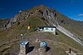
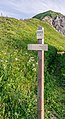
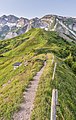
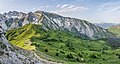
mountain pass of the Alps between Switzerland and France  | |||||
| Upload media | |||||
| Instance of | |||||
|---|---|---|---|---|---|
| Part of | |||||
| Location |
| ||||
| Mountain range | |||||
| Elevation above sea level |
| ||||
| Different from | |||||
 | |||||
Français : Le col de Coux est un col des Préalpes du Nord situé entre le massifs du Giffre et de Chablais, à la limite de la Haute-Savoie (France) et du Valais (Suisse).
Media in category "Col de Cou (Champéry)"
The following 10 files are in this category, out of 10 total.
-
 Col De Cou Barme.jpg 800 × 533; 72 KB
-
 Col de Coux 01.jpg 5,593 × 2,091; 9.19 MB
-
 Col de Coux 02.jpg 5,496 × 3,736; 15.52 MB
-
 Col de Coux 03.jpg 3,635 × 5,453; 8.68 MB
-
 Col de Coux 04.jpg 2,905 × 5,315; 15.57 MB
-
 Col de Coux 05.jpg 3,472 × 5,491; 17.84 MB
-
 Col de Coux 06.jpg 4,335 × 3,061; 11.17 MB
-
 Col de Coux 07.jpg 2,594 × 3,891; 9.92 MB
-
 Rouleau de Bostan 07.jpg 5,618 × 2,984; 12.2 MB
-
 View of Col de Coux.jpg 3,716 × 3,384; 9.55 MB


