Category:Colliery Frantisek in Horní Suchá
The colliery František in Horní Suchá existed between 1911 - 1999.
| Object location | | View all coordinates using: OpenStreetMap |
|---|
 Těžní věž F-4, vysoká 85 m | |||||
| Upload media | |||||
| Instance of | |||||
|---|---|---|---|---|---|
| Location | Horní Suchá, Karviná District, Moravian-Silesian Region, Czechia | ||||
| Inception |
| ||||
| Dissolved, abolished or demolished date |
| ||||
| Horizontal depth |
| ||||
| Area |
| ||||
 | |||||
Media in category "Colliery Frantisek in Horní Suchá"
The following 13 files are in this category, out of 13 total.
-
 Colliery Frantisek Construction of Headframe 2.jpg 789 × 1,268; 284 KB
-
 Colliery Frantisek Construction of Headframe.jpg 1,035 × 1,483; 443 KB
-
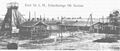 Colliery Frantisek in Horni Sucha 1909 - 1911.jpg 2,123 × 909; 659 KB
-
 Colliery Frantisek.jpg 2,102 × 1,316; 830 KB
-
 Důl František - panoramio - v.sarina.jpg 2,048 × 1,536; 636 KB
-
 Důl František - panoramio.jpg 2,048 × 1,536; 655 KB
-
 Důl František.JPG 1,898 × 2,695; 1,002 KB
-
 Funeral of Wladyslaw Karwinski.jpg 3,192 × 1,987; 2.63 MB
-
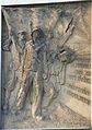 Horni Sucha - pametni deska hornicke stavce 1.JPG 2,682 × 3,808; 3.93 MB
-
 Horni Sucha - pametni deska hornicke stavce 2.JPG 4,608 × 3,456; 6.62 MB
-
 Horní Suchá - 1928.jpg 996 × 663; 81 KB
-
 Pracovni kolonie.jpg 2,082 × 619; 542 KB
-
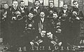 Zachranari Horni Sucha 1938.jpg 3,216 × 2,004; 1.67 MB


