Category:Construction of the Pathfinder Dam
Media in category "Construction of the Pathfinder Dam"
The following 139 files are in this category, out of 139 total.
-
 "Another view of wheat field on Dutch Flats near Mitchell, Nebr." - NARA - 294481.jpg 3,000 × 2,286; 4.5 MB
-

-
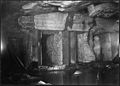
 "Rack in masonry, north side of notch. (Oblique end view.)" - NARA - 294397.jpg 3,000 × 2,112; 935 KB
-
 "Showing character and nature of Scottsbluff, Nebraska." - NARA - 294353.jpg 3,000 × 2,276; 824 KB
-

-
-
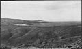
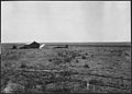
 "Stannard's Camp, showing rolling character of land." - NARA - 294356.jpg 3,000 × 2,270; 802 KB
-
 "Three-foot face stone in storage. Pathfinder Dam." - NARA - 294417.jpg 3,000 × 2,134; 1.01 MB
-
 "Touring thru the irrigated district of the Dutch Flats country." - NARA - 294494.jpg 3,000 × 2,301; 586 KB
-
 "Tristate lateral headgate from opposite bank." - NARA - 294414.jpg 3,000 × 2,128; 583 KB
-

-

-
 "View of Mitchell, Nebraska." - NARA - 294455.jpg 3,000 × 2,315; 959 KB
-

-

-
 Alfalfa field in Pleasant Valley - NARA - 294488.jpg 3,000 × 2,291; 1.09 MB
-

-
 Another view of harvesting wheat crop on Ballantine Thomas ranch - NARA - 294491.jpg 3,000 × 2,264; 1.06 MB
-
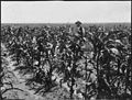 Corn fields on the Dutch Flats near Mitchell, Nebr. - NARA - 294493.jpg 3,000 × 2,264; 1.02 MB
-
 Crops and settlement in Sunflower Valley - NARA - 294482.jpg 3,000 × 2,301; 900 KB
-
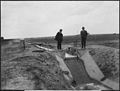
 Drop 1 and lateral out-take in Lateral 21A Canal - NARA - 294458.jpg 3,000 × 2,291; 1.07 MB
-
 Drop 12 - Lateral 21-M Canal - NARA - 294459.jpg 3,000 × 2,333; 1.07 MB
-
 Drop 19 on lateral 15 east - NARA - 294449.jpg 3,000 × 2,265; 844 KB
-
 Drop 3 - Lateral 21-M Canal - NARA - 294460.jpg 3,000 × 2,260; 929 KB
-
 Drop 8 in lateral 21A Canal - NARA - 294456.jpg 3,000 × 2,288; 1.02 MB
-
 Drops in Main Lateral 21 - NARA - 294472.jpg 3,000 × 2,289; 816 KB
-
 Dutch Flats, irrigation under the North Platte Project - NARA - 294447.jpg 3,000 × 2,298; 647 KB
-
 Dutch Flats, lateral 11 - NARA - 294448.jpg 3,000 × 2,295; 650 KB
-
 Dutch Flats, plowing - NARA - 294443.jpg 3,000 × 2,149; 784 KB
-
 Dutch flats, plowing - NARA - 294444.jpg 3,000 × 2,089; 849 KB
-

-
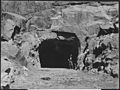 East portal of the Pathfinder Tunnel - NARA - 294360.jpg 3,000 × 2,258; 1.2 MB
-
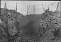
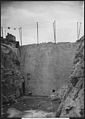
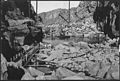 Foundation of Pathfinder Dam - NARA - 294373.jpg 3,000 × 2,026; 893 KB
-

-

-
 Interstate Canal - NARA - 294438.jpg 3,000 × 1,731; 551 KB
-
 Interstate Canal - NARA - 294439.jpg 3,000 × 1,720; 477 KB
-
 Interstate Canal, Spring Canyon flume, looking north - NARA - 294387.jpg 3,000 × 2,106; 788 KB
-
 Interstate Canal. 11-foot drop, lateral No.1, posts - NARA - 294413.jpg 3,000 × 2,184; 861 KB
-
-

-

-
 Interstate Canal. Detailed view of drop basin of Cottonwood flume - NARA - 294402.jpg 3,000 × 2,289; 1.04 MB
-
 Interstate Canal. Distribution gates in laterals DF - NARA - 294416.jpg 3,000 × 2,276; 885 KB
-

-
-

-
 Interstate Canal. Hauphoff culvert - NARA - 294404.jpg 3,000 × 2,232; 1.03 MB
-
 Interstate Canal. Hauphoff flume, looking north. - NARA - 294386.jpg 3,000 × 2,091; 752 KB
-
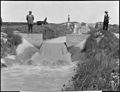
 Interstate Canal. Headgate at Sta. 2088. - NARA - 294383.jpg 3,000 × 2,126; 657 KB
-
 Interstate Canal. Lateral No. 10 headgate. - NARA - 294473.jpg 3,000 × 2,288; 579 KB
-
-
-
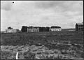
 Interstate Canal. Office Building, Mitchell, Nebr. - NARA - 294384.jpg 3,000 × 2,124; 549 KB
-

-
 Interstate Canal. Patent four wheeled scrapers. - NARA - 294367.jpg 3,000 × 2,161; 646 KB
-

-
 Interstate Canal. Rawhide siphon. - NARA - 294408.jpg 3,000 × 2,252; 645 KB
-
 Interstate Canal. Spillway and railroad crossing at Mollie's Fork. - NARA - 294403.jpg 3,000 × 2,301; 815 KB
-
 Interstate Canal. Spring Canyon flume from northwest. - NARA - 294380.jpg 3,000 × 2,160; 638 KB
-
 Interstate Canal. Spring Canyon flume, side and top view. - NARA - 294407.jpg 3,000 × 2,248; 884 KB
-
 Interstate Canal. Spring Canyon flume. - NARA - 294406.jpg 3,000 × 2,240; 858 KB
-
 Interstate Canal. View showing diversion gate in No. 10 Lateral. - NARA - 294479.jpg 3,000 × 2,314; 564 KB
-
 Interstate Canal. Wet Sheep Creek culvert under construction. - NARA - 294409.jpg 3,000 × 2,227; 1.07 MB
-
 Interstate Canal. Willey Draw culvert. - NARA - 294405.jpg 3,000 × 2,224; 1.2 MB
-

-
 Lateral out-take and drop in lateral 21A - NARA - 294457.jpg 3,000 × 2,257; 933 KB
-
 Lower face of Pathfinder Dam, showing location of loaded drill holes - NARA - 294467.jpg 3,000 × 2,139; 718 KB
-
 Main Canal, looking down - NARA - 294445.jpg 3,000 × 2,246; 585 KB
-
 Main Street, Mitchell, Nebraska - NARA - 294497.jpg 3,000 × 2,268; 958 KB
-
 Mitchell, Nebraska, and the valley about the town - NARA - 294484.jpg 3,000 × 2,318; 836 KB
-
 New residences in the town of Mitchell, Nebr. - NARA - 294495.jpg 3,000 × 2,270; 1.02 MB
-

-
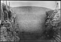
 Pathfinder Dam site looking upstream - NARA - 294364.jpg 2,180 × 3,000; 940 KB
-

-
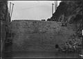
 Pathfinder dam, bed rock in foundation - NARA - 294376.jpg 3,000 × 2,070; 1.07 MB
-
 Pathfinder Dam, bedrock in foundation - NARA - 294374.jpg 3,000 × 2,076; 1 MB
-
 Pathfinder Dam, bulkhead for closing tunnel - NARA - 294400.jpg 3,000 × 2,118; 795 KB
-
 Pathfinder Dam, centrifugal pumps in foundation - NARA - 294366.jpg 3,000 × 1,984; 832 KB
-
 Pathfinder Dam, contractor's plant from south side of canyon - NARA - 294424.jpg 3,000 × 2,099; 843 KB
-
 Pathfinder Dam, crusher and mixing house - NARA - 294382.jpg 3,000 × 2,017; 808 KB
-
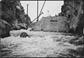
 Pathfinder Dam, diversion flume - NARA - 294365.jpg 3,000 × 2,151; 956 KB
-
 Pathfinder Dam, footbridge across North Platte River - NARA - 294389.jpg 3,000 × 2,084; 857 KB
-
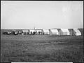
 Pathfinder Dam, freight teams - NARA - 294370.jpg 3,000 × 2,007; 892 KB
-
 Pathfinder Dam, gate-keeper's house - NARA - 294379.jpg 3,000 × 2,047; 1,000 KB
-

-

-
 Pathfinder Dam, guide wall at north end of dam - NARA - 294433.jpg 3,000 × 2,065; 869 KB
-
 Pathfinder Dam, High pressure gates looking upstream - NARA - 294419.jpg 3,000 × 2,068; 672 KB
-
 Pathfinder Dam, High pressure gates, looking downstream - NARA - 294418.jpg 3,000 × 2,155; 794 KB
-
 Pathfinder dam, laying first stone - NARA - 294375.jpg 3,000 × 2,148; 971 KB
-
 Pathfinder Dam, looking upstream - NARA - 294425.jpg 3,000 × 2,095; 764 KB
-
 Pathfinder Dam, lower face - NARA - 294395.jpg 3,000 × 2,057; 781 KB
-
 Pathfinder Dam, lower face - NARA - 294415.jpg 3,000 × 2,145; 708 KB
-
 Pathfinder Dam, lower face - NARA - 294420.jpg 3,000 × 2,210; 700 KB
-
 Pathfinder Dam, lower face - NARA - 294427.jpg 2,106 × 3,000; 717 KB
-
 Pathfinder Dam, lower face during flood - NARA - 294392.jpg 3,000 × 2,063; 688 KB
-
 Pathfinder Dam, Method of closing Pathfinder tunnel - NARA - 294399.jpg 3,000 × 2,049; 846 KB
-

-
 Pathfinder Dam, method of piling cement, looking northwest - NARA - 294422.jpg 3,000 × 2,109; 716 KB
-
 Pathfinder Dam, progress of masonry - NARA - 294381.jpg 3,000 × 2,103; 793 KB
-
 Pathfinder Dam, progress of masonry - NARA - 294385.jpg 3,000 × 2,030; 759 KB
-
 Pathfinder Dam, rack in masonry, north side of notch - NARA - 294396.jpg 3,000 × 2,056; 911 KB
-
 Pathfinder Dam, Upper face - NARA - 294398.jpg 3,000 × 2,069; 656 KB
-
 Pathfinder Dam, upper face - NARA - 294421.jpg 3,000 × 2,135; 696 KB
-
 Pathfinder Dam, upper face - NARA - 294426.jpg 2,105 × 3,000; 669 KB
-
 Pathfinder Dam, upper face - NARA - 294452.jpg 3,000 × 1,977; 664 KB
-
 Pathfinder Dam, upper face - NARA - 294463.jpg 3,000 × 2,084; 807 KB
-
 Pathfinder Dam, upper face at close of 1908 season - NARA - 294428.jpg 2,136 × 3,000; 709 KB
-
 Pathfinder Dam, upper face of dam - NARA - 294391.jpg 3,000 × 2,071; 829 KB
-
-

-
 Pathfinder Dam. Dam during a freshet - NARA - 294394.jpg 3,000 × 2,020; 1,004 KB
-
 Pathfinder Dam. Dam during flood - NARA - 294390.jpg 3,000 × 2,032; 806 KB
-

-
 Pathfinder Dam. Sandbag core wall in temporary dam - NARA - 294363.jpg 3,000 × 2,086; 897 KB
-
 Pathfinder dike, looking south, showing preparation of site - NARA - 294468.jpg 3,000 × 2,142; 749 KB
-
 Pathfinder reservoir, dam, and site of dike at extreme left - NARA - 294377.jpg 3,000 × 2,141; 816 KB
-

-
 Pathfinder tunnel, Construction of grizzly looking northwest - NARA - 294430.jpg 3,000 × 2,156; 706 KB
-
 Pathfinder tunnel, showing boulder lodged in waterway below A gate - NARA - 294461.jpg 3,000 × 2,167; 972 KB
-

-

-
 View showing hauling of balanced valves to the Pathfinder Dam - NARA - 294474.jpg 3,000 × 2,092; 627 KB
-
 View showing hauling of balanced valves to the Pathfinder Dam - NARA - 294475.jpg 3,000 × 2,099; 701 KB
-

-

-
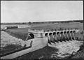
 Whalen diversion dam and headworks - NARA - 294453.jpg 3,000 × 2,131; 3.27 MB
-
 Whalen diversion dam and headworks - NARA - 294454.jpg 3,000 × 2,148; 2.95 MB
-
 Whalen diversion dam and headworks, looking across river from north side - NARA - 294435.jpg 3,000 × 2,108; 3.08 MB
-
 Whalen diversion dam and headworks, looking across river from north side - NARA - 294437.jpg 3,000 × 2,122; 2.89 MB
-
 Whalen diversion dam and headworks, looking up river from north side - NARA - 294436.jpg 3,000 × 2,071; 3.16 MB
-
 Whalen diversion dam, looking down river - NARA - 294434.jpg 3,000 × 2,081; 3.06 MB
-
 Wheat crop on Dr. Blackburn's ranch near Mitchell, Nebraska - NARA - 294487.jpg 3,000 × 2,281; 4.11 MB
-
 Wheat field in shock under the Mitchell ditch, Mitchell Valley - NARA - 294486.jpg 3,000 × 2,340; 4.05 MB
-
 Wheat field near Mitchell, Nebraska - NARA - 294471.jpg 3,000 × 2,276; 3.56 MB
-
 Wheat field on Dutch flats near Mitchell, Nebr. Farm of T.C. Shawver - NARA - 294480.jpg 3,000 × 2,298; 4.54 MB
-
 Wheat in shocks Pleasant Valley, farm of Benj. Martin - NARA - 294483.jpg 3,000 × 2,334; 3.78 MB
-
 Winter Creek Bottom, taken from hill south of Fairchild's place - NARA - 294492.jpg 3,000 × 2,363; 3.7 MB


%22_-_NARA_-_294397.jpg)


