Category:Crawshawbooth
English: Crawshawbooth is a small village in England just north of the market town of Rawtenstall, Lancashire, and a part of the valley of Rossendale. The majority of surrounding land is farm and moor land and many walkers come to the area.
village in United Kingdom  | |||||
| Upload media | |||||
| Instance of | |||||
|---|---|---|---|---|---|
| Location | Rossendale, Lancashire, North West England, England | ||||
 | |||||
Subcategories
This category has the following 8 subcategories, out of 8 total.
Media in category "Crawshawbooth"
The following 48 files are in this category, out of 48 total.
-
 A682, Crawshawbooth - geograph.org.uk - 449315.jpg 640 × 480; 150 KB
-
 A682, Crawshawbooth - geograph.org.uk - 449320.jpg 640 × 480; 100 KB
-
 Black Dog, Crawshawbooth - geograph.org.uk - 801989.jpg 640 × 480; 190 KB
-
 Britannia Mill, Crawshawbooth - geograph.org.uk - 802018.jpg 640 × 480; 196 KB
-

-
 Burnley Road - geograph.org.uk - 1332538.jpg 640 × 462; 73 KB
-
 Burnley Road Crawshawbooth - geograph.org.uk - 478053.jpg 640 × 392; 80 KB
-
 Burnley Road, Crawshawbooth - geograph.org.uk - 1717313.jpg 3,872 × 2,592; 3.04 MB
-
 Burnley Road, Crawshawbooth - geograph.org.uk - 802005.jpg 640 × 480; 187 KB
-
 Co-operation Street, Crawshawbooth - geograph.org.uk - 802014.jpg 640 × 480; 207 KB
-
 Exposed - geograph.org.uk - 802008.jpg 640 × 480; 198 KB
-
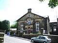 Rakefoot Methodist Church, Crawshawbooth - geograph.org.uk - 449284.jpg 640 × 480; 103 KB
-
 Crawshawbooth - Burnley Road (A682) - geograph.org.uk - 2480623.jpg 3,456 × 2,304; 3.56 MB
-
 Crawshawbooth - geograph.org.uk - 385472.jpg 640 × 480; 89 KB
-
 Crawshawbooth Entrance.jpg 914 × 648; 417 KB
-
 Crawshawbooth-from-rawtenstall.jpg 1,728 × 1,303; 1,022 KB
-
 Goodshaw Baptist Church - geograph.org.uk - 449351.jpg 640 × 480; 147 KB
-
 Limy Water, Crawshawbooth - geograph.org.uk - 802006.jpg 480 × 640; 185 KB
-
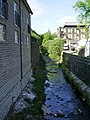 Limy Water, Crawshawbooth - geograph.org.uk - 802017.jpg 480 × 640; 198 KB
-
 Limy Water, Crawshawbooth - geograph.org.uk - 802021.jpg 466 × 622; 191 KB
-
 Limy Water, Crawshawbooth, Lancashire - geograph.org.uk - 1727485.jpg 1,224 × 1,632; 473 KB
-
 Limy Water, Crawshawbooth, Lancashire - geograph.org.uk - 1727486.jpg 1,632 × 1,224; 483 KB
-
 Little Weir - geograph.org.uk - 124212.jpg 640 × 480; 119 KB
-
 Lodge, Crawshaw Hall.jpg 3,648 × 2,736; 4.81 MB
-
 Pink House Goodshaw - geograph.org.uk - 383477.jpg 640 × 480; 99 KB
-
-
 Rake Top Farm - geograph.org.uk - 1717429.jpg 3,872 × 2,592; 4.99 MB
-
-

-
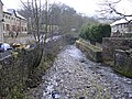
 River Limy - geograph.org.uk - 449332.jpg 640 × 480; 98 KB
-
 River Limy Crawshawbooth - geograph.org.uk - 386356.jpg 640 × 480; 95 KB
-
 Road to Wood Nook, Crawshawbooth - geograph.org.uk - 802016.jpg 640 × 480; 201 KB
-

-
 Rushbed Cottages Crawshawbooth - geograph.org.uk - 385451.jpg 640 × 480; 99 KB
-
 Site of Hawthorn Mill - Folly Clough - geograph.org.uk - 1169602.jpg 640 × 480; 124 KB
-

-

-
 The Glory Burnley Road - geograph.org.uk - 478025.jpg 640 × 348; 55 KB
-
 The Jester Crawshawbooth - geograph.org.uk - 478037.jpg 640 × 385; 74 KB
-
 The River Limy, Crawshawbooth - geograph.org.uk - 449302.jpg 640 × 480; 97 KB
-
 Toll Cottage, Crawshawbooth - geograph.org.uk - 868516.jpg 640 × 480; 89 KB
-
 War Memorial being moved - geograph.org.uk - 1727482.jpg 1,224 × 1,632; 496 KB
-
 WM Club Crawshawbooth Detail - geograph.org.uk - 478065.jpg 640 × 480; 114 KB
-
 Wood Nook, Crawshawbooth - geograph.org.uk - 802019.jpg 640 × 480; 209 KB
-
 Wrecked van on the hills above Crawshawbooth, early 1980s.jpg 1,746 × 1,170; 515 KB
-
 York Street, Crawshawbooth - geograph.org.uk - 449324.jpg 640 × 480; 160 KB
-
 Burnley Road, Crawshawbooth - geograph.org.uk - 1490726.jpg 640 × 375; 53 KB
-
 The Chapel - geograph.org.uk - 449346.jpg 640 × 480; 99 KB


_%22Margaret_Pearson%22,_2005_Volvo_B7TL_Wrightbus_Eclipse_Gemini,_The_Witch_Way,_Crawshawbooth,_9_June_2011.jpg)


_-_geograph.org.uk_-_2480623.jpg)


