Category:Creu de terme (Bellcaire d'Urgell)
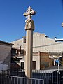
Català: Creu de terme. (Bellcaire d'Urgell)
This is a category about a building listed in the Catalan heritage register as Bé Cultural d'Interès Local (BCIL) under the reference IPA-22142. |
| Object location | | View all coordinates using: OpenStreetMap |
|---|
 | |||||
| Upload media | |||||
| Instance of | |||||
|---|---|---|---|---|---|
| Location | Bellcaire d'Urgell, Noguera, Ponent, Lleida Province, Catalonia | ||||
| Street address |
| ||||
| Architectural style |
| ||||
| Heritage designation |
| ||||
| Inception |
| ||||
| Elevation above sea level |
| ||||
 | |||||
Media in category "Creu de terme (Bellcaire d'Urgell)"
The following 6 files are in this category, out of 6 total.
-
 Bellcaireurgell creu.jpg 180 × 126; 6 KB
-
 CREU DE TERME - BELLCAIRE D'URGELL - IB-833.jpg 1,536 × 2,048; 960 KB
-
 CREU DE TERME - BELLCAIRE D'URGELL - IB-834.jpg 1,536 × 2,048; 936 KB
-
 CREU DE TERME - BELLCAIRE D'URGELL - IB-835.jpg 1,536 × 2,048; 949 KB
-
 CREU DE TERME - BELLCAIRE D'URGELL - IB-836.jpg 1,536 × 2,048; 949 KB
-
 CREU DE TERME - BELLCAIRE D'URGELL - IB-838.jpg 1,536 × 2,048; 1.04 MB


