Category:Croix du Mont
| Object location | | View all coordinates using: OpenStreetMap |
|---|
| Object location | | View all coordinates using: OpenStreetMap |
|---|
|
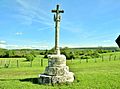
This building is inscrit au titre des monuments historiques de la France. It is indexed in the base Mérimée, a database of architectural heritage maintained by the French Ministry of Culture, under the reference PA00101761
|
wayside cross located in Doubs, in France  | |||||
| Upload media | |||||
| Instance of | |||||
|---|---|---|---|---|---|
| Location | Villers-la-Combe, canton of Pierrefontaine-les-Varans | ||||
| Heritage designation |
| ||||
 | |||||
Media in category "Croix du Mont"
The following 10 files are in this category, out of 10 total.
-
 Calvaire du Mont, daté de 1622, près de l'église.jpg 3,926 × 2,898; 1.63 MB
-
 Croix du Mont 01.JPG 2,736 × 3,648; 2.44 MB
-
 Croix du Mont 02.JPG 2,736 × 3,648; 2.45 MB
-
 Croix du Mont 03.JPG 2,736 × 3,648; 2.41 MB
-
 Croix du Mont 04.JPG 2,736 × 3,648; 2.42 MB
-
 Croix du Mont détail date.JPG 3,648 × 2,736; 2.42 MB
-
 Date sur le socle du calvaire.du mont.jpg 4,000 × 3,000; 3.38 MB
-
 Face est du calvaire du Mont.jpg 4,000 × 3,000; 1.05 MB
-
 Face ouest, du calvaire du Mont.jpg 4,000 × 3,000; 845 KB
-
 Villers-la-Combe, oratoire et calvaire.jpg 4,308 × 2,423; 2.84 MB


