Category:Crosby Green bridge
| Object location | | View all coordinates using: OpenStreetMap |
|---|
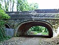
This somewhat dilapidated bridge over the North Liverpool Extension Line previously provided access from the end of Crosby Green to Sefton House, at various times a school opened in 1849 and later the residence of Thomas Utley, a marine engineer and magistrate. The land on which it stood is now part of Holly Lodge school, but I have not discovered when it was demolished. The bridge now appears to be redundant.
Media in category "Crosby Green bridge"
The following 2 files are in this category, out of 2 total.
-
 Crosby Green bridge 1.jpg 4,944 × 3,708; 9.54 MB
-
 Crosby Green bridge 2.jpg 4,764 × 3,630; 9.15 MB

