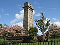
Category:Cumberland and Westmorland Joint Counties’ War Memorial
This is a category about listed building number 1291971. |
| Object location | | View all coordinates using: OpenStreetMap |
|---|
architectural structure in Carlisle, Cumbria, UK  | |||||
| Upload media | |||||
| Instance of | |||||
|---|---|---|---|---|---|
| Location | Carlisle, Cumbria, North West England, England | ||||
| Heritage designation |
| ||||
 | |||||
Media in category "Cumberland and Westmorland Joint Counties’ War Memorial"
The following 2 files are in this category, out of 2 total.
-
 Cenotaph in Rickerby Park - geograph.org.uk - 1283247.jpg 640 × 480; 89 KB
-
 War Memorial - geograph.org.uk - 92900.jpg 640 × 427; 120 KB
