Category:Cure et école annexée (Route des Geais 39, Pleigne)
| Object location | | View all coordinates using: OpenStreetMap |
|---|
building in Pleigne in the canton of Jura, Switzerland  | |||||
| Upload media | |||||
| Instance of | |||||
|---|---|---|---|---|---|
| Part of | |||||
| Location | Pleigne, Delémont District, Jura, Switzerland | ||||
| Street address |
| ||||
| Heritage designation | |||||
 | |||||
Media in category "Cure et école annexée (Route des Geais 39, Pleigne)"
This category contains only the following file.
-
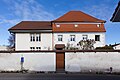 2015-Pleigne-Altes-Schulhaus.jpg 1,500 × 1,000; 1.43 MB