Category:Cushman Dam No. 1
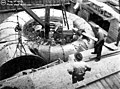
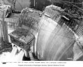
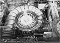
English: Cushman Dam No. 1 is a hydroelectric dam on the North Fork of the Skokomish River in Mason County forming Lake Cushman. It was built by Tacoma City Light (now Tacoma Power) in 1924-1926. Tacoma's demand for electricity grew rapidly after World War I. Tacoma City Light’s Nisqually River Hydroelectric Project, built in 1912, could not meet the demand and the utility decided to build a new hydroelectric project on the North Fork Skokomish River. The dam and powerhouse first began to delivery electricity on February 12, 1926.
| Object location | | View all coordinates using: OpenStreetMap |
|---|
|
This is a category about a place or building that is listed on the National Register of Historic Places in the United States of America. Its reference number is 88002759. |
dam on the North Fork Skokomish River in Washington state listed on National Register of Historic Places  | |||||
| Upload media | |||||
| Instance of | |||||
|---|---|---|---|---|---|
| Location | Mason County, Washington, Pacific Northwest, Washington, Pacific States Region | ||||
| Owned by |
| ||||
| Heritage designation | |||||
| Inception |
| ||||
| Width |
| ||||
| Height |
| ||||
| Elevation above sea level |
| ||||
| Drainage basin |
| ||||
| Reservoir created | |||||
 | |||||
Media in category "Cushman Dam No. 1"
The following 41 files are in this category, out of 41 total.
-

-
 Cushman Dam 1.jpg 4,752 × 3,168; 12.79 MB
-

-
 Cushman Dam No. 1.jpg 4,226 × 3,329; 1.61 MB
-
 Cushman Hydroelectric Project HD NRHP 14001244 Mason County, WA.jpg 3,648 × 2,736; 3.91 MB
-

-

-

-

-

-

-
-

-
-

-

-
-

-

-

-

-

-
-

-

-

-

-

-

-
-

-

-

-

-

-

-

-

-

-

-

.jpg)

.jpg)

.jpg)
.jpg)
.jpg)
.jpg)
.jpg)
.jpg)
.jpg)