Category:Dals-Långeds kyrka
| Object location | | View all coordinates using: OpenStreetMap |
|---|
church building in Bengtsfors Municipality, Älvsborg County, Sweden   | |||||
| Upload media | |||||
| Instance of | |||||
|---|---|---|---|---|---|
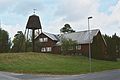
| Location | Dals Långed, Dalsland, Götaland, Sweden | ||||
| Diocese | |||||
| Has use | |||||
| Occupant | |||||
| Heritage designation |
| ||||
| Inception |
| ||||
| Date of official opening |
| ||||
| official website | |||||
 | |||||
Svenska: Dals-Långeds kyrka tillhör Steneby-Tisselskogs församling, Steneby pastorat, Dalslands kontrakt, Karlstads stift / Diocese of Karlstad.
|
This is a category about an ecclesiastical monument in Sweden, number 21300000002325 (sub-number: 21400000443880) in the RAÄ buildings database.
|
Subcategories
This category has only the following subcategory.
I
Media in category "Dals-Långeds kyrka"
The following 3 files are in this category, out of 3 total.
-
 DalsLångedskyrka21500001452169.jpg 1,840 × 1,232; 804 KB
-
 DalsLångedskyrka21500001452170.jpg 1,840 × 1,232; 876 KB
-
 DalsLångedskyrka21500001452171.jpg 1,840 × 1,232; 843 KB

