Category:De Boschkamp, De Lutte
| Object location | | View all coordinates using: OpenStreetMap |
|---|
 | |||||
| Upload media | |||||
| Instance of | |||||
|---|---|---|---|---|---|
| Location | De Lutte, Losser, Overijssel, Netherlands | ||||
| Street address |
| ||||
| Located on street |
| ||||
| Heritage designation |
| ||||
 | |||||
|
This is a category about rijksmonument number 513515
|
|
This is a category about a municipal monument in Losser with number WN012 |
| Address |
|
Media in category "De Boschkamp, De Lutte"
The following 10 files are in this category, out of 10 total.
-
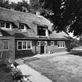
 Achtergevel - De Lutte - 20053341 - RCE.jpg 1,200 × 961; 268 KB
-
 Achtergevel - De Lutte - 20053346 - RCE.jpg 1,188 × 1,200; 429 KB
-
 De-Lutte-Bentheimerstraat-16.jpg 2,421 × 1,221; 1.17 MB
-
 Linker zijgevel - De Lutte - 20053344 - RCE.jpg 1,200 × 1,188; 451 KB
-
 Linker zijgevel - De Lutte - 20053345 - RCE.jpg 1,197 × 1,200; 430 KB
-
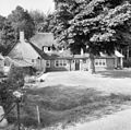
 Overzicht - De Lutte - 20053338 - RCE.jpg 1,200 × 956; 241 KB
-
 Voor- en linker zijgevel - De Lutte - 20053343 - RCE.jpg 1,190 × 1,200; 443 KB
-
 Voorgevel - De Lutte - 20053339 - RCE.jpg 1,200 × 951; 231 KB
-
 Voorgevel - De Lutte - 20053340 - RCE.jpg 1,200 × 963; 231 KB
-
 Voorgevel - De Lutte - 20053342 - RCE.jpg 1,186 × 1,200; 395 KB


