Category:De Haghe
| Camera location | | View all coordinates using: OpenStreetMap |
|---|
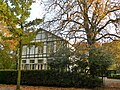
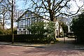
Nederlands: Afbeeldingen van het landhuis De Haghe, Haagweg 339 in de wijk Princenhage in het zuidwesten van Breda in de provincie Noord-Brabant in het zuiden van Nederland.
|
This is a category about rijksmonument number 519007
|
building in Breda, Netherlands  | |||||
| Upload media | |||||
| Instance of | |||||
|---|---|---|---|---|---|
| Location | Breda, North Brabant, Netherlands | ||||
| Street address |
| ||||
| Heritage designation |
| ||||
 | |||||
Media in category "De Haghe"
The following 3 files are in this category, out of 3 total.
-
 De Haghe P1030573copy.jpg 3,264 × 2,448; 3.27 MB
-
 De Haghe.JPG 3,008 × 2,000; 5.86 MB
-
 Haagweg Princenhage DSCF7257.JPG 4,000 × 3,000; 4.83 MB

